Xuanzhou geodata
Xuanzhou (Anhui) is a populated place; located in China in Asia/Shanghai (GMT+8) time zone. With population of 127,758 people, there are 342 cities with bigger population in this country. Compared to other cities in China, 54.4% of cities are located further ↓South; 74.7% of cities are located further ←West and 80.8% of cities have higher elevation than Xuanzhou. Note1


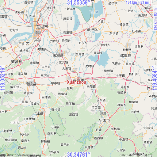
Xuanzhou GPS coordinates[2]
30° 57' 9" North, 118° 45' 19.008" East
| Map corner | latitude | longitude |
|---|---|---|
| Upper-left | 31.55359°, | 118.05216° |
| Center: | 30.9525°, | 118.75528° |
| Lower-right: | 30.34761°, | 119.45841° |
| Map W x H: | 134.1×134.1 km | = 83.3×83.3mi |
| max Lat: | 53.31946° ⇑45.6% North |
| Xuanzhou: | 30.9525° |
| min Lat: | ⇓54.4% South 18.22056° |
| min Long | Xuanzhou | max Long |
| 75.07348° | 118.75528° | 134.28917° |
| W 74.7%⇐ | ⇒25.3% E |
Elevation
Elevation of Xuanzhou is 25 m = 82 ft, and this is 459.8 m = 1509 ft below average elevation for this country.
| Max E: |
5622 m = 18445 ft | 80.8% |
| Avg. | 484.8 m = 1591 ft | |
| Xuanzhou | 25 m = 82 ft | |
Min E: |
-3 m = -10 ft | 19.2% |
See also: Xuanzhou elevation on elevation.city.
Geographical zone
Xuanzhou is located in North temperate zone (between Tropic of Cancer and the Arctic Circle). Distance of this Northern Tropic circle is 835.7 km =519.3 mi to South.| Distance of | km | miles | from Xuanzhou |
|---|---|---|---|
| North Pole | 6565.5 | 4079.6 | to North |
| Arctic Circle | 3959.6 | 2460.4 | to North |
| Tropic Cancer | 835.7 | 519.3 | to South |
| Equator | 3441.6 | 2138.5 | to South |


Nearby cities:
15 places around Xuanzhou: (largest is in red/bold)
• Dingdian
10.7 km =6.6 mi,  71°
71°
• Guquan
13.6 km =8.5 mi,  310°
310°
• Hanting
20.1 km =12.5 mi,  259°
259°
• Jinba
11.5 km =7.1 mi,  225°
225°
• Rencunwan
15.5 km =9.6 mi,  1°
1°
• Sanyuan
19.2 km =11.9 mi,  317°
317°
• Shencun
14.3 km =8.9 mi,  39°
39°
• Shuangxi
4.7 km =2.9 mi,  82°
82°
• Sunbu
13.5 km =8.4 mi,  115°
115°
• Tianhu
15.6 km =9.7 mi, 255°
• Wuxing
6.8 km =4.2 mi,  21°
21°
• Xiadu
3.9 km =2.4 mi,  146°
146°
• Xiangyang
12.4 km =7.7 mi, 120°
• Yangliu
18.7 km =11.6 mi, 227°
• Yishan
15.1 km =9.4 mi,  157°
157°
Sources, notices
• [Note1] Compared only with cities in China existing in our database
• [Src1] Map data: © OpenStreetMap contributors (CC-BY-SA)
• [Src2] Other city data from geonames.org with taken over terms of usage.
• [Src3] Geographical zone / Annual Mean Temperature by Robert A. Rohde @ Wikipedia
