Tianhu geodata
Tianhu (Anhui) is a seat of a fourth-order administrative division; located in China in Asia/Shanghai (GMT+8) time zone. In our database, there are 1268 cities with bigger population. Compared to other cities in China, 54.1% of cities are located further ↓South; 73.8% of cities are located further ←West and 73% of cities have higher elevation than Tianhu. Note1


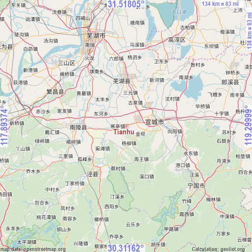
Tianhu GPS coordinates[2]
30° 55' 0.264" North, 118° 35' 48.696" East
| Map corner | latitude | longitude |
|---|---|---|
| Upper-left | 31.51805°, | 117.89374° |
| Center: | 30.91674°, | 118.59686° |
| Lower-right: | 30.31162°, | 119.29999° |
| Map W x H: | 134.1×134.1 km | = 83.3×83.3mi |
| max Lat: | 53.31946° ⇑45.9% North |
| Tianhu: | 30.91674° |
| min Lat: | ⇓54.1% South 18.22056° |
| min Long | Tianhu | max Long |
| 75.07348° | 118.59686° | 134.28917° |
| W 73.8%⇐ | ⇒26.2% E |
Elevation
Elevation of Tianhu is 42 m = 138 ft, and this is 442.8 m = 1453 ft below average elevation for this country.
| Max E: |
5622 m = 18445 ft | 73% |
| Avg. | 484.8 m = 1591 ft | |
| Tianhu | 42 m = 138 ft | |
Min E: |
-3 m = -10 ft | 27% |
See also: China elevation on elevation.city.
Geographical zone
Tianhu is located in North temperate zone (between Tropic of Cancer and the Arctic Circle). Distance of this Northern Tropic circle is 831.7 km =516.8 mi to South.| Distance of | km | miles | from Tianhu |
|---|---|---|---|
| North Pole | 6569.4 | 4082 | to North |
| Arctic Circle | 3963.6 | 2462.9 | to North |
| Tropic Cancer | 831.7 | 516.8 | to South |
| Equator | 3437.6 | 2136 | to South |


Nearby cities:
15 places around Tianhu: (largest is in red/bold)
• Donghe
15.1 km =9.4 mi,  297°
297°
• Gaoqiao
13.2 km =8.2 mi,  189°
189°
• Guquan
13.7 km =8.5 mi,  20°
20°
• Hanting
4.6 km =2.9 mi,  272°
272°
• Jinba
8.1 km =5 mi,  120°
120°
• Sanyuan
18.3 km =11.4 mi,  6°
6°
• Shuangxi
20.3 km =12.6 mi,  76°
76°
• Taifeng
19.4 km =12.1 mi,  318°
318°
• Wenchang
10.4 km =6.5 mi,  262°
262°
• Xiadu
17.3 km =10.7 mi,  87°
87°
• Xihe
14.3 km =8.9 mi,  305°
305°
• Xuanzhou
15.6 km =9.7 mi, 75°
• Yangliu
8.9 km =5.5 mi,  170°
170°
• Yijiang
10.6 km =6.6 mi, 264°
• Zhouwang
19.2 km =11.9 mi,  154°
154°
Sources, notices
• [Note1] Compared only with cities in China existing in our database
• [Src1] Map data: © OpenStreetMap contributors (CC-BY-SA)
• [Src2] Other city data from geonames.org with taken over terms of usage.
• [Src3] Geographical zone / Annual Mean Temperature by Robert A. Rohde @ Wikipedia
