Xiushan geodata
Xiushan (Hunan) is a seat of a fourth-order administrative division; located in China in Asia/Shanghai (GMT+8) time zone. In our database, there are 1268 cities with bigger population. Compared to other cities in China, 68.9% of cities are located further ↑North; 62.6% of cities are located further →East and 75.7% of cities have higher elevation than Xiushan. Note1


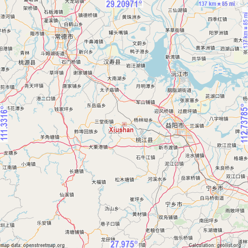
Xiushan GPS coordinates[2]
28° 35' 39.012" North, 112° 2' 4.992" East
| Map corner | latitude | longitude |
|---|---|---|
| Upper-left | 29.20971°, | 111.3316° |
| Center: | 28.59417°, | 112.03472° |
| Lower-right: | 27.975°, | 112.73785° |
| Map W x H: | 137.3×137.3 km | = 85.3×85.3mi |
| max Lat: | 53.31946° ⇑68.9% North |
| Xiushan: | 28.59417° |
| min Lat: | ⇓31.1% South 18.22056° |
| min Long | Xiushan | max Long |
| 75.07348° | 112.03472° | 134.28917° |
| W 37.4%⇐ | ⇒62.6% E |
Elevation
Elevation of Xiushan is 35 m = 115 ft, and this is 449.8 m = 1476 ft below average elevation for this country.
| Max E: |
5622 m = 18445 ft | 75.7% |
| Avg. | 484.8 m = 1591 ft | |
| Xiushan | 35 m = 115 ft | |
Min E: |
-3 m = -10 ft | 24.3% |
See also: China elevation on elevation.city.
Geographical zone
Xiushan is located in North temperate zone (between Tropic of Cancer and the Arctic Circle). Distance of this Northern Tropic circle is 573.5 km =356.4 mi to South.| Distance of | km | miles | from Xiushan |
|---|---|---|---|
| North Pole | 6827.7 | 4242.5 | to North |
| Arctic Circle | 4221.8 | 2623.3 | to North |
| Tropic Cancer | 573.5 | 356.4 | to South |
| Equator | 3179.4 | 1975.6 | to South |


Nearby cities:
15 places around Xiushan: (largest is in red/bold)
• Cuijiaqiao
12.2 km =7.6 mi,  343°
343°
• Damatou
29.6 km =18.4 mi,  84°
84°
• Junshanpu
17.6 km =10.9 mi,  45°
45°
• Luojiaping
24.6 km =15.3 mi,  272°
272°
• Shiniujiang
21.6 km =13.4 mi,  145°
145°
• Silihe
29 km =18 mi,  225°
225°
• Taohuajiang
11.8 km =7.3 mi,  131°
131°
• Wuqishan
10.5 km =6.5 mi,  298°
298°
• Wutan
28.5 km =17.7 mi,  252°
252°
• Xinqiaohe
14.9 km =9.3 mi, 83°
• Xinshidu
26.6 km =16.5 mi,  115°
115°
• Yingfengqiao
23.5 km =14.6 mi,  71°
71°
• Yiyang
28.7 km =17.8 mi,  91°
91°
• Zhujiapu
30 km =18.6 mi,  307°
307°
• Zhumushan
26.7 km =16.6 mi,  345°
345°
Sources, notices
• [Note1] Compared only with cities in China existing in our database
• [Src1] Map data: © OpenStreetMap contributors (CC-BY-SA)
• [Src2] Other city data from geonames.org with taken over terms of usage.
• [Src3] Geographical zone / Annual Mean Temperature by Robert A. Rohde @ Wikipedia
