Yiyang geodata
Yiyang (Hunan) is a populated place; located in China in Asia/Shanghai (GMT+8) time zone. With population of 202,608 people, there are 228 cities with bigger population in this country. Compared to other cities in China, 69% of cities are located further ↑North; 61% of cities are located further →East and 80.8% of cities have higher elevation than Yiyang. Note1


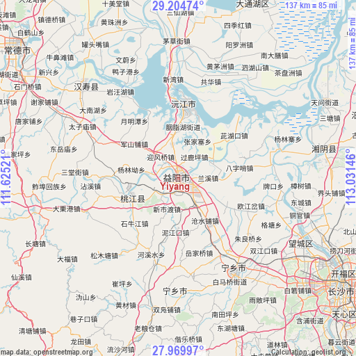
Yiyang GPS coordinates[2]
28° 35' 21.012" North, 112° 19' 41.988" East
| Map corner | latitude | longitude |
|---|---|---|
| Upper-left | 29.20474°, | 111.62521° |
| Center: | 28.58917°, | 112.32833° |
| Lower-right: | 27.96997°, | 113.03146° |
| Map W x H: | 137.3×137.3 km | = 85.3×85.3mi |
| max Lat: | 53.31946° ⇑69% North |
| Yiyang: | 28.58917° |
| min Lat: | ⇓31% South 18.22056° |
| min Long | Yiyang | max Long |
| 75.07348° | 112.32833° | 134.28917° |
| W 39%⇐ | ⇒61% E |
Elevation
Elevation of Yiyang is 25 m = 82 ft, and this is 459.8 m = 1509 ft below average elevation for this country.
| Max E: |
5622 m = 18445 ft | 80.8% |
| Avg. | 484.8 m = 1591 ft | |
| Yiyang | 25 m = 82 ft | |
Min E: |
-3 m = -10 ft | 19.2% |
See also: Yiyang elevation on elevation.city.
Geographical zone
Yiyang is located in North temperate zone (between Tropic of Cancer and the Arctic Circle). Distance of this Northern Tropic circle is 572.9 km =356 mi to South.| Distance of | km | miles | from Yiyang |
|---|---|---|---|
| North Pole | 6828.2 | 4242.8 | to North |
| Arctic Circle | 4222.4 | 2623.7 | to North |
| Tropic Cancer | 572.9 | 356 | to South |
| Equator | 3178.8 | 1975.2 | to South |


Nearby cities:
15 places around Yiyang: (largest is in red/bold)
• Bazishao
23.4 km =14.5 mi,  81°
81°
• Cangshuipu
19.6 km =12.2 mi,  147°
147°
• Cihukou
26.9 km =16.7 mi,  53°
53°
• Damatou
3.3 km =2.1 mi,  14°
14°
• Heshan
2.3 km =1.4 mi,  109°
109°
• Jiangjiazui
27.9 km =17.3 mi,  337°
337°
• Junshanpu
20.5 km =12.7 mi,  308°
308°
• Qionghu
28.3 km =17.6 mi, 9°
• Sanyantang
20 km =12.4 mi, 8°
• Shiniujiang
24 km =14.9 mi,  223°
223°
• Taohuajiang
21.1 km =13.1 mi,  249°
249°
• Xinqiaohe
14 km =8.7 mi,  278°
278°
• Xinshidu
12 km =7.5 mi,  202°
202°
• Xiushan
28.7 km =17.8 mi,  271°
271°
• Yingfengqiao
10.2 km =6.3 mi,  321°
321°
Sources, notices
• [Note1] Compared only with cities in China existing in our database
• [Src1] Map data: © OpenStreetMap contributors (CC-BY-SA)
• [Src2] Other city data from geonames.org with taken over terms of usage.
• [Src3] Geographical zone / Annual Mean Temperature by Robert A. Rohde @ Wikipedia
