Wutan geodata
Wutan (Hunan) is a seat of a fourth-order administrative division; located in China in Asia/Shanghai (GMT+8) time zone. In our database, there are 1268 cities with bigger population. Compared to other cities in China, 69.6% of cities are located further ↑North; 63.7% of cities are located further →East and 65.8% of cities have higher elevation than Wutan. Note1


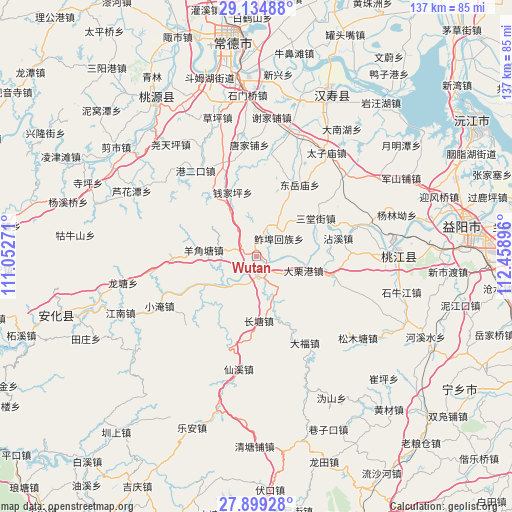
Wutan GPS coordinates[2]
28° 31' 8.004" North, 111° 45' 20.988" East
| Map corner | latitude | longitude |
|---|---|---|
| Upper-left | 29.13488°, | 111.05271° |
| Center: | 28.51889°, | 111.75583° |
| Lower-right: | 27.89928°, | 112.45896° |
| Map W x H: | 137.4×137.4 km | = 85.4×85.4mi |
| max Lat: | 53.31946° ⇑69.6% North |
| Wutan: | 28.51889° |
| min Lat: | ⇓30.4% South 18.22056° |
| min Long | Wutan | max Long |
| 75.07348° | 111.75583° | 134.28917° |
| W 36.3%⇐ | ⇒63.7% E |
Elevation
Elevation of Wutan is 69 m = 226 ft, and this is 415.8 m = 1364 ft below average elevation for this country.
| Max E: |
5622 m = 18445 ft | 65.8% |
| Avg. | 484.8 m = 1591 ft | |
| Wutan | 69 m = 226 ft | |
Min E: |
-3 m = -10 ft | 34.2% |
See also: China elevation on elevation.city.
Geographical zone
Wutan is located in North temperate zone (between Tropic of Cancer and the Arctic Circle). Distance of this Northern Tropic circle is 565.1 km =351.1 mi to South.| Distance of | km | miles | from Wutan |
|---|---|---|---|
| North Pole | 6836.1 | 4247.8 | to North |
| Arctic Circle | 4230.2 | 2628.5 | to North |
| Tropic Cancer | 565.1 | 351.1 | to South |
| Equator | 3171 | 1970.4 | to South |


Nearby cities:
15 places around Wutan: (largest is in red/bold)
• Changmaoling
33.3 km =20.7 mi,  333°
333°
• Changtang
18 km =11.2 mi,  174°
174°
• Cuijiaqiao
31.2 km =19.4 mi,  49°
49°
• Huangtudian
24.8 km =15.4 mi,  342°
342°
• Longtang
35.6 km =22.1 mi,  256°
256°
• Luojiaping
9.7 km =6 mi,  16°
16°
• Nijiangping
30.8 km =19.1 mi,  310°
310°
• Qianjiaping
16.6 km =10.3 mi, 342°
• Silihe
13.6 km =8.5 mi,  151°
151°
• Wuqishan
22.4 km =13.9 mi, 53°
• Xianxi
30.9 km =19.2 mi,  189°
189°
• Xiejiapu
35.2 km =21.9 mi,  7°
7°
• Xiushan
28.5 km =17.7 mi,  72°
72°
• Yangjiaotang
13.2 km =8.2 mi,  277°
277°
• Zhujiapu
27 km =16.8 mi, 7°
Sources, notices
• [Note1] Compared only with cities in China existing in our database
• [Src1] Map data: © OpenStreetMap contributors (CC-BY-SA)
• [Src2] Other city data from geonames.org with taken over terms of usage.
• [Src3] Geographical zone / Annual Mean Temperature by Robert A. Rohde @ Wikipedia
