Guixi geodata
Guixi (Jiangxi) is a seat of a third-order administrative division; located in China in Asia/Shanghai (GMT+8) time zone. With population of 73,732 people, there are 580 cities with bigger population in this country. Compared to other cities in China, 71.6% of cities are located further ↑North; 67.3% of cities are located further ←West and 70.3% of cities have higher elevation than Guixi. Note1


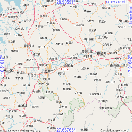
Guixi GPS coordinates[2]
28° 17' 18.852" North, 117° 12' 47.844" East
| Map corner | latitude | longitude |
|---|---|---|
| Upper-left | 28.90591°, | 116.51017° |
| Center: | 28.28857°, | 117.21329° |
| Lower-right: | 27.66763°, | 117.91642° |
| Map W x H: | 137.7×137.7 km | = 85.6×85.6mi |
| max Lat: | 53.31946° ⇑71.6% North |
| Guixi: | 28.28857° |
| min Lat: | ⇓28.4% South 18.22056° |
| min Long | Guixi | max Long |
| 75.07348° | 117.21329° | 134.28917° |
| W 67.3%⇐ | ⇒32.7% E |
Elevation
Elevation of Guixi is 51 m = 167 ft, and this is 433.8 m = 1423 ft below average elevation for this country.
| Max E: |
5622 m = 18445 ft | 70.3% |
| Avg. | 484.8 m = 1591 ft | |
| Guixi | 51 m = 167 ft | |
Min E: |
-3 m = -10 ft | 29.7% |
See also: Guixi elevation on elevation.city.
Geographical zone
Guixi is located in North temperate zone (between Tropic of Cancer and the Arctic Circle). Distance of this Northern Tropic circle is 539.5 km =335.2 mi to South.| Distance of | km | miles | from Guixi |
|---|---|---|---|
| North Pole | 6861.7 | 4263.7 | to North |
| Arctic Circle | 4255.8 | 2644.4 | to North |
| Tropic Cancer | 539.5 | 335.2 | to South |
| Equator | 3145.4 | 1954.5 | to South |


Nearby cities:
15 places around Guixi: (largest is in red/bold)
• Binjiang
2.9 km =1.8 mi,  284°
284°
• Gangkou
16.5 km =10.3 mi,  131°
131°
• Guifeng
16.3 km =10.1 mi,  75°
75°
• Hetan
12 km =7.5 mi,  42°
42°
• Hongtang
20.7 km =12.9 mi,  291°
291°
• Jianzhu
11.3 km =7 mi,  103°
103°
• Jintun
18.2 km =11.3 mi,  175°
175°
• Liukou
4.4 km =2.7 mi, 100°
• Luohe
9.4 km =5.8 mi,  201°
201°
• Pengwan
23.2 km =14.4 mi, 202°
• Qinghu
14.9 km =9.3 mi,  65°
65°
• Sili
13.2 km =8.2 mi,  339°
339°
• Xuguang
20.8 km =12.9 mi, 96°
• Yujia
22.6 km =14 mi,  235°
235°
• Zhiguang
15.6 km =9.7 mi,  301°
301°
Sources, notices
• [Note1] Compared only with cities in China existing in our database
• [Src1] Map data: © OpenStreetMap contributors (CC-BY-SA)
• [Src2] Other city data from geonames.org with taken over terms of usage.
• [Src3] Geographical zone / Annual Mean Temperature by Robert A. Rohde @ Wikipedia
