Qinghu geodata
Qinghu (Jiangxi) is a seat of a fourth-order administrative division; located in China in Asia/Shanghai (GMT+8) time zone. In our database, there are 1268 cities with bigger population. Compared to other cities in China, 71.1% of cities are located further ↑North; 68.1% of cities are located further ←West and 73.3% of cities have higher elevation than Qinghu. Note1


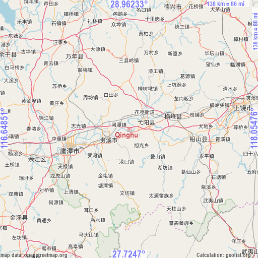
Qinghu GPS coordinates[2]
28° 20' 43.152" North, 117° 21' 5.868" East
| Map corner | latitude | longitude |
|---|---|---|
| Upper-left | 28.96233°, | 116.64851° |
| Center: | 28.34532°, | 117.35163° |
| Lower-right: | 27.7247°, | 118.05476° |
| Map W x H: | 137.6×137.6 km | = 85.5×85.5mi |
| max Lat: | 53.31946° ⇑71.1% North |
| Qinghu: | 28.34532° |
| min Lat: | ⇓28.9% South 18.22056° |
| min Long | Qinghu | max Long |
| 75.07348° | 117.35163° | 134.28917° |
| W 68.1%⇐ | ⇒31.9% E |
Elevation
Elevation of Qinghu is 41 m = 135 ft, and this is 443.8 m = 1456 ft below average elevation for this country.
| Max E: |
5622 m = 18445 ft | 73.3% |
| Avg. | 484.8 m = 1591 ft | |
| Qinghu | 41 m = 135 ft | |
Min E: |
-3 m = -10 ft | 26.7% |
See also: China elevation on elevation.city.
Geographical zone
Qinghu is located in North temperate zone (between Tropic of Cancer and the Arctic Circle). Distance of this Northern Tropic circle is 545.8 km =339.1 mi to South.| Distance of | km | miles | from Qinghu |
|---|---|---|---|
| North Pole | 6855.4 | 4259.7 | to North |
| Arctic Circle | 4249.5 | 2640.5 | to North |
| Tropic Cancer | 545.8 | 339.1 | to South |
| Equator | 3151.7 | 1958.4 | to South |


Nearby cities:
15 places around Qinghu: (largest is in red/bold)
• Binjiang
17.3 km =10.7 mi,  251°
251°
• Gangkou
17.3 km =10.7 mi,  184°
184°
• Gexi
16.9 km =10.5 mi,  38°
38°
• Guifeng
3.1 km =1.9 mi,  134°
134°
• Guixi
14.9 km =9.3 mi, 245°
• Hetan
6 km =3.7 mi,  295°
295°
• Huating
13.2 km =8.2 mi, 41°
• Jianzhu
9.4 km =5.8 mi,  195°
195°
• Liukou
11.7 km =7.3 mi,  232°
232°
• Nanyan
11.2 km =7 mi,  57°
57°
• Wang’er
17.3 km =10.7 mi,  111°
111°
• Wanli
12.2 km =7.6 mi,  9°
9°
• Xuguang
11.2 km =7 mi,  140°
140°
• Yiyang
10.3 km =6.4 mi,  49°
49°
• Zhukeng
16.6 km =10.3 mi,  71°
71°
Sources, notices
• [Note1] Compared only with cities in China existing in our database
• [Src1] Map data: © OpenStreetMap contributors (CC-BY-SA)
• [Src2] Other city data from geonames.org with taken over terms of usage.
• [Src3] Geographical zone / Annual Mean Temperature by Robert A. Rohde @ Wikipedia
