Jintun geodata
Jintun (Jiangxi) is a seat of a fourth-order administrative division; located in China in Asia/Shanghai (GMT+8) time zone. In our database, there are 1268 cities with bigger population. Compared to other cities in China, 73.1% of cities are located further ↑North; 67.4% of cities are located further ←West and 60.6% of cities have higher elevation than Jintun. Note1


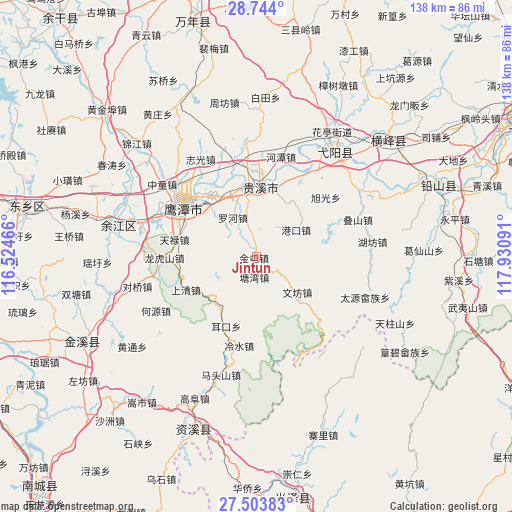
Jintun GPS coordinates[2]
28° 7' 32.556" North, 117° 13' 40.008" East
| Map corner | latitude | longitude |
|---|---|---|
| Upper-left | 28.744°, | 116.52466° |
| Center: | 28.12571°, | 117.22778° |
| Lower-right: | 27.50383°, | 117.93091° |
| Map W x H: | 137.9×137.9 km | = 85.7×85.7mi |
| max Lat: | 53.31946° ⇑73.1% North |
| Jintun: | 28.12571° |
| min Lat: | ⇓26.9% South 18.22056° |
| min Long | Jintun | max Long |
| 75.07348° | 117.22778° | 134.28917° |
| W 67.4%⇐ | ⇒32.6% E |
Elevation
Elevation of Jintun is 95 m = 312 ft, and this is 389.8 m = 1279 ft below average elevation for this country.
| Max E: |
5622 m = 18445 ft | 60.6% |
| Avg. | 484.8 m = 1591 ft | |
| Jintun | 95 m = 312 ft | |
Min E: |
-3 m = -10 ft | 39.4% |
See also: China elevation on elevation.city.
Geographical zone
Jintun is located in North temperate zone (between Tropic of Cancer and the Arctic Circle). Distance of this Northern Tropic circle is 521.4 km =324 mi to South.| Distance of | km | miles | from Jintun |
|---|---|---|---|
| North Pole | 6879.8 | 4274.9 | to North |
| Arctic Circle | 4273.9 | 2655.7 | to North |
| Tropic Cancer | 521.4 | 324 | to South |
| Equator | 3127.3 | 1943.2 | to South |


Nearby cities:
15 places around Jintun: (largest is in red/bold)
• Binjiang
19.3 km =12 mi,  347°
347°
• Erkou
20.3 km =12.6 mi,  203°
203°
• Gangkou
13.1 km =8.1 mi,  56°
56°
• Guixi
18.2 km =11.3 mi,  355°
355°
• Jianzhu
18.1 km =11.2 mi,  31°
31°
• Lengshui
24.5 km =15.2 mi,  189°
189°
• Liukou
17.6 km =10.9 mi,  9°
9°
• Longhushan
24.7 km =15.3 mi,  269°
269°
• Luohe
10.6 km =6.6 mi,  332°
332°
• Pengwan
10.8 km =6.7 mi,  251°
251°
• Shangqing
20.9 km =13 mi,  244°
244°
• Tangwan
5.5 km =3.4 mi, 185°
• Wenfang
14.6 km =9.1 mi,  131°
131°
• Yujia
20.8 km =12.9 mi,  285°
285°
• Zhangping
23.8 km =14.8 mi, 127°
Sources, notices
• [Note1] Compared only with cities in China existing in our database
• [Src1] Map data: © OpenStreetMap contributors (CC-BY-SA)
• [Src2] Other city data from geonames.org with taken over terms of usage.
• [Src3] Geographical zone / Annual Mean Temperature by Robert A. Rohde @ Wikipedia
