Gangkou geodata
Gangkou (Jiangxi) is a seat of a fourth-order administrative division; located in China in Asia/Shanghai (GMT+8) time zone. In our database, there are 1268 cities with bigger population. Compared to other cities in China, 72.5% of cities are located further ↑North; 68% of cities are located further ←West and 69.7% of cities have higher elevation than Gangkou. Note1


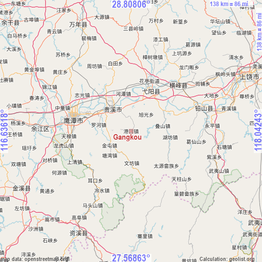
Gangkou GPS coordinates[2]
28° 11' 24.504" North, 117° 20' 21.48" East
| Map corner | latitude | longitude |
|---|---|---|
| Upper-left | 28.80806°, | 116.63618° |
| Center: | 28.19014°, | 117.3393° |
| Lower-right: | 27.56863°, | 118.04243° |
| Map W x H: | 137.8×137.8 km | = 85.6×85.6mi |
| max Lat: | 53.31946° ⇑72.5% North |
| Gangkou: | 28.19014° |
| min Lat: | ⇓27.5% South 18.22056° |
| min Long | Gangkou | max Long |
| 75.07348° | 117.3393° | 134.28917° |
| W 68%⇐ | ⇒32% E |
Elevation
Elevation of Gangkou is 53 m = 174 ft, and this is 431.8 m = 1417 ft below average elevation for this country.
| Max E: |
5622 m = 18445 ft | 69.7% |
| Avg. | 484.8 m = 1591 ft | |
| Gangkou | 53 m = 174 ft | |
Min E: |
-3 m = -10 ft | 30.3% |
See also: China elevation on elevation.city.
Geographical zone
Gangkou is located in North temperate zone (between Tropic of Cancer and the Arctic Circle). Distance of this Northern Tropic circle is 528.5 km =328.4 mi to South.| Distance of | km | miles | from Gangkou |
|---|---|---|---|
| North Pole | 6872.6 | 4270.4 | to North |
| Arctic Circle | 4266.7 | 2651.2 | to North |
| Tropic Cancer | 528.5 | 328.4 | to South |
| Equator | 3134.4 | 1947.6 | to South |


Nearby cities:
15 places around Gangkou: (largest is in red/bold)
• Binjiang
19.1 km =11.9 mi,  307°
307°
• Dieshan
16.8 km =10.4 mi,  80°
80°
• Guifeng
15.5 km =9.6 mi,  12°
12°
• Guixi
16.5 km =10.3 mi, 311°
• Hetan
20.2 km =12.6 mi,  347°
347°
• Hufang
20.9 km =13 mi,  98°
98°
• Jianzhu
8.3 km =5.2 mi, 350°
• Jintun
13.1 km =8.1 mi,  236°
236°
• Liukou
13 km =8.1 mi,  321°
321°
• Luohe
16 km =9.9 mi,  277°
277°
• Qinghu
17.3 km =10.7 mi,  4°
4°
• Tangwan
17.1 km =10.6 mi,  222°
222°
• Wang’er
20.6 km =12.8 mi,  57°
57°
• Wenfang
16.8 km =10.4 mi,  180°
180°
• Xuguang
12.1 km =7.5 mi,  43°
43°
Sources, notices
• [Note1] Compared only with cities in China existing in our database
• [Src1] Map data: © OpenStreetMap contributors (CC-BY-SA)
• [Src2] Other city data from geonames.org with taken over terms of usage.
• [Src3] Geographical zone / Annual Mean Temperature by Robert A. Rohde @ Wikipedia
