Xincheng geodata
Xincheng (Guangdong) is a seat of a third-order administrative division; located in China in Asia/Shanghai (GMT+8) time zone. In our database, there are 1268 cities with bigger population. Compared to other cities in China, 95.7% of cities are located further ↑North; 61.5% of cities are located further →East and 76.7% of cities have higher elevation than Xincheng. Note1


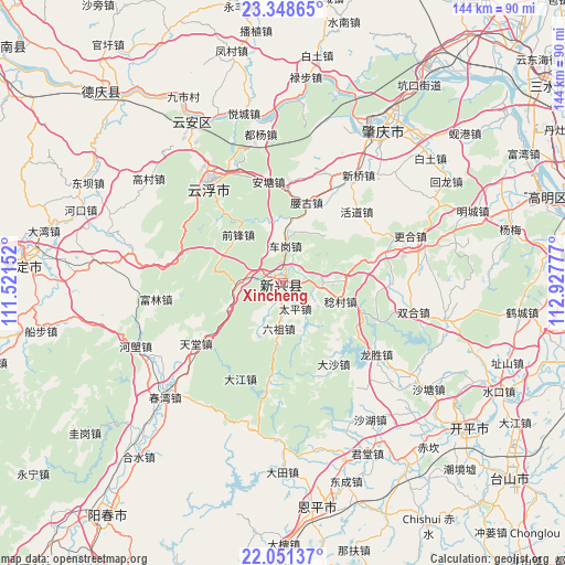
Xincheng GPS coordinates[2]
22° 42' 5.58" North, 112° 13' 28.704" East
| Map corner | latitude | longitude |
|---|---|---|
| Upper-left | 23.34865°, | 111.52152° |
| Center: | 22.70155°, | 112.22464° |
| Lower-right: | 22.05137°, | 112.92777° |
| Map W x H: | 144.2×144.2 km | = 89.6×89.6mi |
| max Lat: | 53.31946° ⇑95.7% North |
| Xincheng: | 22.70155° |
| min Lat: | ⇓4.3% South 18.22056° |
| min Long | Xincheng | max Long |
| 75.07348° | 112.22464° | 134.28917° |
| W 38.5%⇐ | ⇒61.5% E |
Elevation
Elevation of Xincheng is 33 m = 108 ft, and this is 451.8 m = 1482 ft below average elevation for this country.
| Max E: |
5622 m = 18445 ft | 76.7% |
| Avg. | 484.8 m = 1591 ft | |
| Xincheng | 33 m = 108 ft | |
Min E: |
-3 m = -10 ft | 23.3% |
See also: China elevation on elevation.city.
Geographical zone
Xincheng is located in North Torrid zone (between Equator and Tropic of Cancer). Distance of this Northern Tropic circle is 81.7 km =50.8 mi to North.| Distance of | km | miles | from Xincheng |
|---|---|---|---|
| North Pole | 7482.9 | 4649.7 | to North |
| Arctic Circle | 4877 | 3030.4 | to North |
| Tropic Cancer | 81.7 | 50.8 | to North |
| Equator | 2524.2 | 1568.5 | to South |


Nearby cities:
15 places around Xincheng: (largest is in red/bold)
• Antang
25.4 km =15.8 mi,  354°
354°
• Chegang
8.5 km =5.3 mi,  7°
7°
• Dasha
23.6 km =14.7 mi,  148°
148°
• Dongcheng
9.8 km =6.1 mi,  99°
99°
• Hetou
22.7 km =14.1 mi,  235°
235°
• Huodao
26.4 km =16.4 mi,  46°
46°
• Lezhu
11.3 km =7 mi,  266°
266°
• Lidong
26.4 km =16.4 mi,  189°
189°
• Liuzu
11.5 km =7.1 mi, 185°
• Nansheng
21.8 km =13.5 mi,  310°
310°
• Rencun
15.3 km =9.5 mi,  107°
107°
• Shuitai
26.6 km =16.5 mi, 110°
• Silao
25.3 km =15.7 mi,  0°
0°
• Taiping
6.8 km =4.2 mi,  168°
168°
• Yaogu
22 km =13.7 mi,  15°
15°
Sources, notices
• [Note1] Compared only with cities in China existing in our database
• [Src1] Map data: © OpenStreetMap contributors (CC-BY-SA)
• [Src2] Other city data from geonames.org with taken over terms of usage.
• [Src3] Geographical zone / Annual Mean Temperature by Robert A. Rohde @ Wikipedia
