Silao geodata
Silao (Guangdong) is a seat of a fourth-order administrative division; located in China in Asia/Shanghai (GMT+8) time zone. In our database, there are 1268 cities with bigger population. Compared to other cities in China, 94.9% of cities are located further ↑North; 61.5% of cities are located further →East and 74.1% of cities have higher elevation than Silao. Note1


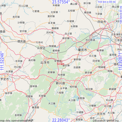
Silao GPS coordinates[2]
22° 55' 46.308" North, 112° 13' 32.088" East
| Map corner | latitude | longitude |
|---|---|---|
| Upper-left | 23.57554°, | 111.52246° |
| Center: | 22.92953°, | 112.22558° |
| Lower-right: | 22.28043°, | 112.92871° |
| Map W x H: | 144×144 km | = 89.5×89.5mi |
| max Lat: | 53.31946° ⇑94.9% North |
| Silao: | 22.92953° |
| min Lat: | ⇓5.1% South 18.22056° |
| min Long | Silao | max Long |
| 75.07348° | 112.22558° | 134.28917° |
| W 38.5%⇐ | ⇒61.5% E |
Elevation
Elevation of Silao is 39 m = 128 ft, and this is 445.8 m = 1463 ft below average elevation for this country.
| Max E: |
5622 m = 18445 ft | 74.1% |
| Avg. | 484.8 m = 1591 ft | |
| Silao | 39 m = 128 ft | |
Min E: |
-3 m = -10 ft | 25.9% |
See also: China elevation on elevation.city.
Geographical zone
Silao is located in North Torrid zone (between Equator and Tropic of Cancer). Distance of this Northern Tropic circle is 56.4 km =35 mi to North.| Distance of | km | miles | from Silao |
|---|---|---|---|
| North Pole | 7457.5 | 4633.9 | to North |
| Arctic Circle | 4851.6 | 3014.6 | to North |
| Tropic Cancer | 56.4 | 35 | to North |
| Equator | 2549.5 | 1584.2 | to South |


Nearby cities:
15 places around Silao: (largest is in red/bold)
• Antang
2.4 km =1.5 mi,  269°
269°
• Baizhu
12.5 km =7.8 mi,  78°
78°
• Chegang
17 km =10.6 mi,  176°
176°
• Dawan
21.8 km =13.5 mi,  53°
53°
• Duyang
12.4 km =7.7 mi,  321°
321°
• Gaofeng
19.1 km =11.9 mi,  279°
279°
• Hekou
12.4 km =7.7 mi,  287°
287°
• Huodao
20.2 km =12.6 mi,  110°
110°
• Liantang
23.5 km =14.6 mi, 83°
• Nansheng
20.2 km =12.6 mi,  236°
236°
• Xinqiao
19.1 km =11.9 mi, 81°
• Yaogu
7.1 km =4.4 mi,  125°
125°
• Yuecheng
20.6 km =12.8 mi,  331°
331°
• Yuncheng
18.1 km =11.2 mi, 274°
• Yunfu
19.1 km =11.9 mi, 269°
Sources, notices
• [Note1] Compared only with cities in China existing in our database
• [Src1] Map data: © OpenStreetMap contributors (CC-BY-SA)
• [Src2] Other city data from geonames.org with taken over terms of usage.
• [Src3] Geographical zone / Annual Mean Temperature by Robert A. Rohde @ Wikipedia
