Rencun geodata
Rencun (Guangdong) is a seat of a fourth-order administrative division; located in China in Asia/Shanghai (GMT+8) time zone. In our database, there are 1268 cities with bigger population. Compared to other cities in China, 95.8% of cities are located further ↑North; 60.8% of cities are located further →East and 71.3% of cities have higher elevation than Rencun. Note1


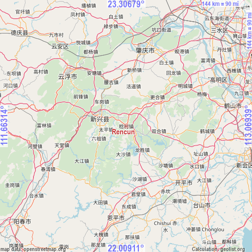
Rencun GPS coordinates[2]
22° 39' 34.128" North, 112° 21' 58.536" East
| Map corner | latitude | longitude |
|---|---|---|
| Upper-left | 23.30679°, | 111.66314° |
| Center: | 22.65948°, | 112.36626° |
| Lower-right: | 22.00911°, | 113.06939° |
| Map W x H: | 144.3×144.3 km | = 89.7×89.7mi |
| max Lat: | 53.31946° ⇑95.8% North |
| Rencun: | 22.65948° |
| min Lat: | ⇓4.2% South 18.22056° |
| min Long | Rencun | max Long |
| 75.07348° | 112.36626° | 134.28917° |
| W 39.2%⇐ | ⇒60.8% E |
Elevation
Elevation of Rencun is 47 m = 154 ft, and this is 437.8 m = 1436 ft below average elevation for this country.
| Max E: |
5622 m = 18445 ft | 71.3% |
| Avg. | 484.8 m = 1591 ft | |
| Rencun | 47 m = 154 ft | |
Min E: |
-3 m = -10 ft | 28.7% |
See also: China elevation on elevation.city.
Geographical zone
Rencun is located in North Torrid zone (between Equator and Tropic of Cancer). Distance of this Northern Tropic circle is 86.4 km =53.7 mi to North.| Distance of | km | miles | from Rencun |
|---|---|---|---|
| North Pole | 7487.6 | 4652.6 | to North |
| Arctic Circle | 4881.7 | 3033.3 | to North |
| Tropic Cancer | 86.4 | 53.7 | to North |
| Equator | 2519.5 | 1565.5 | to South |


Nearby cities:
15 places around Rencun: (largest is in red/bold)
• Cangcheng
27.5 km =17.1 mi,  137°
137°
• Chegang
18.7 km =11.6 mi,  314°
314°
• Dasha
15.6 km =9.7 mi,  188°
188°
• Dongcheng
5.7 km =3.5 mi,  301°
301°
• Genghe
25.8 km =16 mi,  57°
57°
• Huodao
23.4 km =14.5 mi,  11°
11°
• Lezhu
26.1 km =16.2 mi,  278°
278°
• Liuzu
17.1 km =10.6 mi,  246°
246°
• Longsheng
16 km =9.9 mi, 143°
• Magang
24 km =14.9 mi,  147°
147°
• Shuitai
11.3 km =7 mi,  113°
113°
• Taiping
13.3 km =8.3 mi,  261°
261°
• Xincheng
15.3 km =9.5 mi,  287°
287°
• Yaogu
27.3 km =17 mi,  341°
341°
• Zhaiwu
27.3 km =17 mi,  99°
99°
Sources, notices
• [Note1] Compared only with cities in China existing in our database
• [Src1] Map data: © OpenStreetMap contributors (CC-BY-SA)
• [Src2] Other city data from geonames.org with taken over terms of usage.
• [Src3] Geographical zone / Annual Mean Temperature by Robert A. Rohde @ Wikipedia
