Xinxiang geodata
Xinxiang (Henan) is a seat of a second-order administrative division; located in China in Asia/Shanghai (GMT+8) time zone. With population of 743,601 people, there are 82 cities with bigger population in this country. Compared to other cities in China, 75.4% of cities are located further ↓South; 52.5% of cities are located further →East and 63.1% of cities have higher elevation than Xinxiang. Note1


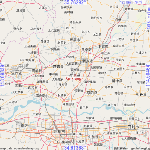
Xinxiang GPS coordinates[2]
35° 11' 25.188" North, 113° 48' 5.436" East
| Map corner | latitude | longitude |
|---|---|---|
| Upper-left | 35.76292°, | 113.09839° |
| Center: | 35.19033°, | 113.80151° |
| Lower-right: | 34.61368°, | 114.50464° |
| Map W x H: | 127.8×127.8 km | = 79.4×79.4mi |
| max Lat: | 53.31946° ⇑24.6% North |
| Xinxiang: | 35.19033° |
| min Lat: | ⇓75.4% South 18.22056° |
| min Long | Xinxiang | max Long |
| 75.07348° | 113.80151° | 134.28917° |
| W 47.5%⇐ | ⇒52.5% E |
Elevation
Elevation of Xinxiang is 82 m = 269 ft, and this is 402.8 m = 1322 ft below average elevation for this country.
| Max E: |
5622 m = 18445 ft | 63.1% |
| Avg. | 484.8 m = 1591 ft | |
| Xinxiang | 82 m = 269 ft | |
Min E: |
-3 m = -10 ft | 36.9% |
See also: Xinxiang elevation on elevation.city.
Geographical zone
Xinxiang is located in North temperate zone (between Tropic of Cancer and the Arctic Circle). Distance of this Northern Tropic circle is 1306.9 km =812.1 mi to South.| Distance of | km | miles | from Xinxiang |
|---|---|---|---|
| North Pole | 6094.3 | 3786.8 | to North |
| Arctic Circle | 3488.4 | 2167.6 | to North |
| Tropic Cancer | 1306.9 | 812.1 | to South |
| Equator | 3912.8 | 2431.3 | to South |


Nearby cities:
15 places around Xinxiang: (largest is in red/bold)
• Chaoge
57.9 km =36 mi,  37°
37°
• Chengguan
29.8 km =18.5 mi,  359°
359°
• Chengjiao
33.5 km =20.8 mi, 44°
• Fengqiu Chengguanzhen
58.4 km =36.3 mi,  107°
107°
• Huaihelu
54.7 km =34 mi,  195°
195°
• Huojia Chengguanzhen
16.1 km =10 mi,  301°
301°
• Jianshelu
51.7 km =32.1 mi, 200°
• Jiaozuo
51.9 km =32.2 mi,  276°
276°
• Mucheng
38.9 km =24.2 mi,  254°
254°
• Xiuwu Chengguanzhen
33.3 km =20.7 mi, 277°
• Yanjin Chengguanzhen
35.5 km =22.1 mi,  98°
98°
• Yuanwu
21.8 km =13.5 mi,  186°
186°
• Yuanyang Chengguanzhen
21.3 km =13.2 mi,  136°
136°
• Zhengzhou
50.1 km =31.1 mi, 196°
• Zhongmu Chengguanzhen
55.3 km =34.4 mi,  164°
164°
Sources, notices
• [Note1] Compared only with cities in China existing in our database
• [Src1] Map data: © OpenStreetMap contributors (CC-BY-SA)
• [Src2] Other city data from geonames.org with taken over terms of usage.
• [Src3] Geographical zone / Annual Mean Temperature by Robert A. Rohde @ Wikipedia
