Zhengzhou geodata
Zhengzhou (Henan) is a seat of a first-order administrative division; located in China in Asia/Shanghai (GMT+8) time zone. With population of 4,253,913 people, there are 19 cities with bigger population in this country. Compared to other cities in China, 74.1% of cities are located further ↓South; 53.4% of cities are located further →East and 59% of cities have higher elevation than Zhengzhou. Note1


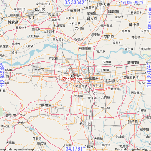
Zhengzhou GPS coordinates[2]
34° 45' 28.008" North, 113° 38' 54.996" East
| Map corner | latitude | longitude |
|---|---|---|
| Upper-left | 35.33342°, | 112.94549° |
| Center: | 34.75778°, | 113.64861° |
| Lower-right: | 34.1781°, | 114.35174° |
| Map W x H: | 128.5×128.5 km | = 79.8×79.8mi |
| max Lat: | 53.31946° ⇑25.9% North |
| Zhengzhou: | 34.75778° |
| min Lat: | ⇓74.1% South 18.22056° |
| min Long | Zhengzhou | max Long |
| 75.07348° | 113.64861° | 134.28917° |
| W 46.6%⇐ | ⇒53.4% E |
Elevation
Elevation of Zhengzhou is 104 m = 341 ft, and this is 380.8 m = 1249 ft below average elevation for this country.
| Max E: |
5622 m = 18445 ft | 59% |
| Avg. | 484.8 m = 1591 ft | |
| Zhengzhou | 104 m = 341 ft | |
Min E: |
-3 m = -10 ft | 41% |
See also: Zhengzhou elevation on elevation.city.
Geographical zone
Zhengzhou is located in North temperate zone (between Tropic of Cancer and the Arctic Circle). Distance of this Northern Tropic circle is 1258.8 km =782.2 mi to South.| Distance of | km | miles | from Zhengzhou |
|---|---|---|---|
| North Pole | 6142.4 | 3816.7 | to North |
| Arctic Circle | 3536.5 | 2197.5 | to North |
| Tropic Cancer | 1258.8 | 782.2 | to South |
| Equator | 3864.7 | 2401.4 | to South |


Nearby cities:
15 places around Zhengzhou: (largest is in red/bold)
• Huaihelu
4.7 km =2.9 mi,  188°
188°
• Huojia Chengguanzhen
56.5 km =35.1 mi,  0°
0°
• Jianshelu
3.9 km =2.4 mi,  262°
262°
• Jiyuanlu
35.6 km =22.1 mi,  281°
281°
• Kaifeng
60.3 km =37.5 mi,  85°
85°
• Mucheng
44.3 km =27.5 mi,  327°
327°
• Qingping
35.1 km =21.8 mi,  225°
225°
• Suohe
26.7 km =16.6 mi, 277°
• Wenquan
56.1 km =34.9 mi,  290°
290°
• Xinhualu
40.8 km =25.4 mi,  170°
170°
• Xinxiang
50.1 km =31.1 mi,  16°
16°
• Xiuwu Chengguanzhen
56 km =34.8 mi,  339°
339°
• Yuanwu
28.8 km =17.9 mi, 23°
• Yuanyang Chengguanzhen
43.6 km =27.1 mi,  41°
41°
• Zhongmu Chengguanzhen
29.4 km =18.3 mi,  100°
100°
Sources, notices
• [Note1] Compared only with cities in China existing in our database
• [Src1] Map data: © OpenStreetMap contributors (CC-BY-SA)
• [Src2] Other city data from geonames.org with taken over terms of usage.
• [Src3] Geographical zone / Annual Mean Temperature by Robert A. Rohde @ Wikipedia
