Mucheng geodata
Mucheng (Henan) is a seat of a third-order administrative division; located in China in Asia/Shanghai (GMT+8) time zone. In our database, there are 1268 cities with bigger population. Compared to other cities in China, 75.3% of cities are located further ↓South; 55% of cities are located further →East and 60.4% of cities have higher elevation than Mucheng. Note1


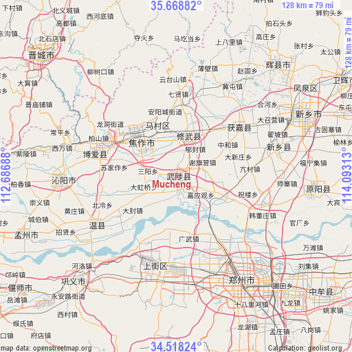
Mucheng GPS coordinates[2]
35° 5' 44.016" North, 113° 23' 24" East
| Map corner | latitude | longitude |
|---|---|---|
| Upper-left | 35.66882°, | 112.68688° |
| Center: | 35.09556°, | 113.39° |
| Lower-right: | 34.51824°, | 114.09313° |
| Map W x H: | 127.9×127.9 km | = 79.5×79.5mi |
| max Lat: | 53.31946° ⇑24.7% North |
| Mucheng: | 35.09556° |
| min Lat: | ⇓75.3% South 18.22056° |
| min Long | Mucheng | max Long |
| 75.07348° | 113.39° | 134.28917° |
| W 45%⇐ | ⇒55% E |
Elevation
Elevation of Mucheng is 96 m = 315 ft, and this is 388.8 m = 1276 ft below average elevation for this country.
| Max E: |
5622 m = 18445 ft | 60.4% |
| Avg. | 484.8 m = 1591 ft | |
| Mucheng | 96 m = 315 ft | |
Min E: |
-3 m = -10 ft | 39.6% |
See also: China elevation on elevation.city.
Geographical zone
Mucheng is located in North temperate zone (between Tropic of Cancer and the Arctic Circle). Distance of this Northern Tropic circle is 1296.3 km =805.5 mi to South.| Distance of | km | miles | from Mucheng |
|---|---|---|---|
| North Pole | 6104.8 | 3793.3 | to North |
| Arctic Circle | 3498.9 | 2174.1 | to North |
| Tropic Cancer | 1296.3 | 805.5 | to South |
| Equator | 3902.3 | 2424.8 | to South |


Nearby cities:
15 places around Mucheng: (largest is in red/bold)
• Changping
45.1 km =28 mi,  290°
290°
• Huaihelu
48 km =29.8 mi,  151°
151°
• Huojia Chengguanzhen
30.3 km =18.8 mi,  51°
51°
• Jianshelu
42.8 km =26.6 mi, 152°
• Jiaozuo
21.5 km =13.4 mi,  318°
318°
• Jiyuanlu
32.4 km =20.1 mi,  200°
200°
• Qinghua
30.8 km =19.1 mi,  284°
284°
• Suohe
34.4 km =21.4 mi,  184°
184°
• Tanbei
41 km =25.5 mi,  268°
268°
• Wenquan
33.9 km =21.1 mi,  238°
238°
• Xinxiang
38.9 km =24.2 mi,  74°
74°
• Xiuwu Chengguanzhen
15.7 km =9.8 mi,  16°
16°
• Yuanwu
36.8 km =22.9 mi,  107°
107°
• Zhengzhou
44.3 km =27.5 mi, 147°
• Zhongzhan
26.4 km =16.4 mi,  307°
307°
Sources, notices
• [Note1] Compared only with cities in China existing in our database
• [Src1] Map data: © OpenStreetMap contributors (CC-BY-SA)
• [Src2] Other city data from geonames.org with taken over terms of usage.
• [Src3] Geographical zone / Annual Mean Temperature by Robert A. Rohde @ Wikipedia
