Chengjiao geodata
Chengjiao (Henan) is a seat of a third-order administrative division; located in China in Asia/Shanghai (GMT+8) time zone. In our database, there are 1268 cities with bigger population. Compared to other cities in China, 75.8% of cities are located further ↓South; 50.9% of cities are located further →East and 65.3% of cities have higher elevation than Chengjiao. Note1


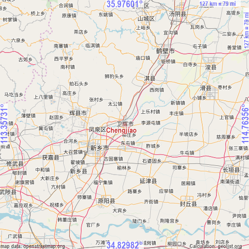
Chengjiao GPS coordinates[2]
35° 24' 17.82" North, 114° 3' 37.548" East
| Map corner | latitude | longitude |
|---|---|---|
| Upper-left | 35.97601°, | 113.35731° |
| Center: | 35.40495°, | 114.06043° |
| Lower-right: | 34.82982°, | 114.76356° |
| Map W x H: | 127.4×127.4 km | = 79.2×79.2mi |
| max Lat: | 53.31946° ⇑24.2% North |
| Chengjiao: | 35.40495° |
| min Lat: | ⇓75.8% South 18.22056° |
| min Long | Chengjiao | max Long |
| 75.07348° | 114.06043° | 134.28917° |
| W 49.1%⇐ | ⇒50.9% E |
Elevation
Elevation of Chengjiao is 71 m = 233 ft, and this is 413.8 m = 1358 ft below average elevation for this country.
| Max E: |
5622 m = 18445 ft | 65.3% |
| Avg. | 484.8 m = 1591 ft | |
| Chengjiao | 71 m = 233 ft | |
Min E: |
-3 m = -10 ft | 34.7% |
See also: China elevation on elevation.city.
Geographical zone
Chengjiao is located in North temperate zone (between Tropic of Cancer and the Arctic Circle). Distance of this Northern Tropic circle is 1330.7 km =826.9 mi to South.| Distance of | km | miles | from Chengjiao |
|---|---|---|---|
| North Pole | 6070.4 | 3772 | to North |
| Arctic Circle | 3464.5 | 2152.7 | to North |
| Tropic Cancer | 1330.7 | 826.9 | to South |
| Equator | 3936.7 | 2446.2 | to South |


Nearby cities:
15 places around Chengjiao: (largest is in red/bold)
• Chaoge
25.1 km =15.6 mi,  27°
27°
• Chengguan
24.5 km =15.2 mi,  284°
284°
• Daokou
44 km =27.3 mi,  66°
66°
• Fengqiu Chengguanzhen
52.6 km =32.7 mi,  142°
142°
• Hebi
56.2 km =34.9 mi,  12°
12°
• Huojia Chengguanzhen
40.3 km =25 mi,  247°
247°
• Puxi
61.3 km =38.1 mi,  112°
112°
• Tangyang Chengguanzhen
62.6 km =38.9 mi, 25°
• Xinxiang
33.5 km =20.8 mi,  224°
224°
• Xiuwu Chengguanzhen
59.7 km =37.1 mi, 251°
• Xun Xian Chengguanzhen
51.7 km =32.1 mi,  56°
56°
• Yanjin Chengguanzhen
31.6 km =19.6 mi,  158°
158°
• Yigou
50.8 km =31.6 mi, 27°
• Yuanwu
52.4 km =32.6 mi,  209°
209°
• Yuanyang Chengguanzhen
40.2 km =25 mi,  192°
192°
Sources, notices
• [Note1] Compared only with cities in China existing in our database
• [Src1] Map data: © OpenStreetMap contributors (CC-BY-SA)
• [Src2] Other city data from geonames.org with taken over terms of usage.
• [Src3] Geographical zone / Annual Mean Temperature by Robert A. Rohde @ Wikipedia
