Xinwo geodata
Xinwo (Zhejiang) is a seat of a fourth-order administrative division; located in China in Asia/Shanghai (GMT+8) time zone. In our database, there are 1268 cities with bigger population. Compared to other cities in China, 65.9% of cities are located further ↑North; 84.3% of cities are located further ←West and 63.3% of cities have lower elevation than Xinwo. Note1


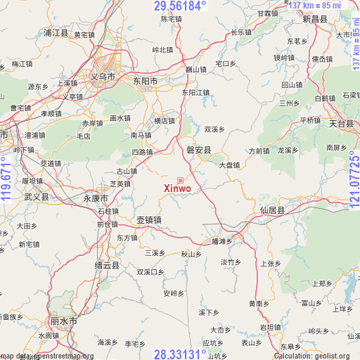
Xinwo GPS coordinates[2]
28° 56' 54.24" North, 120° 22' 26.832" East
| Map corner | latitude | longitude |
|---|---|---|
| Upper-left | 29.56184°, | 119.671° |
| Center: | 28.9484°, | 120.37412° |
| Lower-right: | 28.33131°, | 121.07725° |
| Map W x H: | 136.8×136.8 km | = 85×85mi |
| max Lat: | 53.31946° ⇑65.9% North |
| Xinwo: | 28.9484° |
| min Lat: | ⇓34.1% South 18.22056° |
| min Long | Xinwo | max Long |
| 75.07348° | 120.37412° | 134.28917° |
| W 84.3%⇐ | ⇒15.7% E |
Elevation
Elevation of Xinwo is 302 m = 991 ft, and this is 182.8 m = 600 ft below average elevation for this country.
| Max E: |
5622 m = 18445 ft | 36.7% |
| Avg. | 484.8 m = 1591 ft | |
| Xinwo | 302 m = 991 ft | |
Min E: |
-3 m = -10 ft | 63.3% |
See also: China elevation on elevation.city.
Geographical zone
Xinwo is located in North temperate zone (between Tropic of Cancer and the Arctic Circle). Distance of this Northern Tropic circle is 612.8 km =380.8 mi to South.| Distance of | km | miles | from Xinwo |
|---|---|---|---|
| North Pole | 6788.3 | 4218.1 | to North |
| Arctic Circle | 4182.4 | 2598.8 | to North |
| Tropic Cancer | 612.8 | 380.8 | to South |
| Equator | 3218.8 | 2000.1 | to South |


Nearby cities:
15 places around Xinwo: (largest is in red/bold)
• Anwen
13.8 km =8.6 mi,  26°
26°
• Baizhu
9.7 km =6 mi,  243°
243°
• Fangjun
18.6 km =11.6 mi,  317°
317°
• Fangyan
18.1 km =11.2 mi,  266°
266°
• Gao’er
20.3 km =12.6 mi,  97°
97°
• Huzhen
19.6 km =12.2 mi,  217°
217°
• Lengshui
6 km =3.7 mi,  206°
206°
• Mazhai
16.1 km =10 mi,  357°
357°
• Panfeng
16.2 km =10.1 mi,  93°
93°
• Pan’an
13.2 km =8.2 mi, 27°
• Qianxiang
12 km =7.5 mi,  330°
330°
• Sanlian
10.8 km =6.7 mi,  344°
344°
• Shuangfeng
8.5 km =5.3 mi,  107°
107°
• Xuetian
19.3 km =12 mi,  71°
71°
• Yanling
15.3 km =9.5 mi, 213°
Sources, notices
• [Note1] Compared only with cities in China existing in our database
• [Src1] Map data: © OpenStreetMap contributors (CC-BY-SA)
• [Src2] Other city data from geonames.org with taken over terms of usage.
• [Src3] Geographical zone / Annual Mean Temperature by Robert A. Rohde @ Wikipedia
