Xinmiao geodata
Xinmiao (Chongqing) is a seat of a fourth-order administrative division; located in China in Asia/Shanghai (GMT+8) time zone. In our database, there are 1268 cities with bigger population. Compared to other cities in China, 58% of cities are located further ↑North; 83.5% of cities are located further →East and 69.4% of cities have lower elevation than Xinmiao. Note1


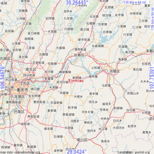
Xinmiao GPS coordinates[2]
29° 39' 19.008" North, 107° 2' 59.568" East
| Map corner | latitude | longitude |
|---|---|---|
| Upper-left | 30.26445°, | 106.34676° |
| Center: | 29.65528°, | 107.04988° |
| Lower-right: | 29.0424°, | 107.75301° |
| Map W x H: | 135.9×135.9 km | = 84.4×84.4mi |
| max Lat: | 53.31946° ⇑58% North |
| Xinmiao: | 29.65528° |
| min Lat: | ⇓42% South 18.22056° |
| min Long | Xinmiao | max Long |
| 75.07348° | 107.04988° | 134.28917° |
| W 16.5%⇐ | ⇒83.5% E |
Elevation
Elevation of Xinmiao is 400 m = 1312 ft, and this is 84.8 m = 278 ft below average elevation for this country.
| Max E: |
5622 m = 18445 ft | 30.6% |
| Avg. | 484.8 m = 1591 ft | |
| Xinmiao | 400 m = 1312 ft | |
Min E: |
-3 m = -10 ft | 69.4% |
See also: China elevation on elevation.city.
Geographical zone
Xinmiao is located in North temperate zone (between Tropic of Cancer and the Arctic Circle). Distance of this Northern Tropic circle is 691.4 km =429.6 mi to South.| Distance of | km | miles | from Xinmiao |
|---|---|---|---|
| North Pole | 6709.7 | 4169.2 | to North |
| Arctic Circle | 4103.8 | 2550 | to North |
| Tropic Cancer | 691.4 | 429.6 | to South |
| Equator | 3297.4 | 2048.9 | to South |


Nearby cities:
15 places around Xinmiao: (largest is in red/bold)
• Baozi
13.3 km =8.3 mi,  113°
113°
• Fengsheng
17.8 km =11.1 mi,  219°
219°
• Huimin
18.2 km =11.3 mi,  104°
104°
• Jiangnan
15.4 km =9.6 mi,  355°
355°
• Lianghui
5.4 km =3.4 mi, 114°
• Linshi
13.8 km =8.6 mi,  84°
84°
• Luoqi
13 km =8.1 mi,  300°
300°
• Maliuzui
11.1 km =6.9 mi,  292°
292°
• Mingjia
16.9 km =10.5 mi,  176°
176°
• Shihe
8.4 km =5.2 mi,  0°
0°
• Shituo
10.7 km =6.6 mi,  50°
50°
• Shuanghekou
13.4 km =8.3 mi,  252°
252°
• Yihe
18.7 km =11.6 mi,  60°
60°
• Zengfu
17.2 km =10.7 mi,  201°
201°
• Zhen’an
12 km =7.5 mi, 54°
Sources, notices
• [Note1] Compared only with cities in China existing in our database
• [Src1] Map data: © OpenStreetMap contributors (CC-BY-SA)
• [Src2] Other city data from geonames.org with taken over terms of usage.
• [Src3] Geographical zone / Annual Mean Temperature by Robert A. Rohde @ Wikipedia
