Zengfu geodata
Zengfu (Chongqing) is a seat of a fourth-order administrative division; located in China in Asia/Shanghai (GMT+8) time zone. In our database, there are 1268 cities with bigger population. Compared to other cities in China, 59.6% of cities are located further ↑North; 83.7% of cities are located further →East and 72.9% of cities have lower elevation than Zengfu. Note1


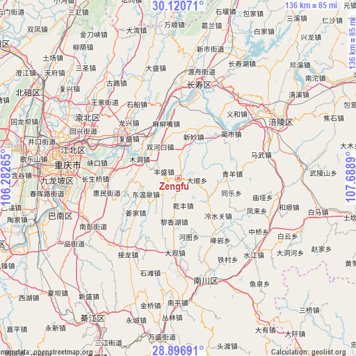
Zengfu GPS coordinates[2]
29° 30' 38.376" North, 106° 59' 8.772" East
| Map corner | latitude | longitude |
|---|---|---|
| Upper-left | 30.12071°, | 106.28265° |
| Center: | 29.51066°, | 106.98577° |
| Lower-right: | 28.89691°, | 107.6889° |
| Map W x H: | 136.1×136.1 km | = 84.6×84.6mi |
| max Lat: | 53.31946° ⇑59.6% North |
| Zengfu: | 29.51066° |
| min Lat: | ⇓40.4% South 18.22056° |
| min Long | Zengfu | max Long |
| 75.07348° | 106.98577° | 134.28917° |
| W 16.3%⇐ | ⇒83.7% E |
Elevation
Elevation of Zengfu is 473 m = 1552 ft, and this is 11.8 m = 39 ft below average elevation for this country.
| Max E: |
5622 m = 18445 ft | 27.1% |
| Avg. | 484.8 m = 1591 ft | |
| Zengfu | 473 m = 1552 ft | |
Min E: |
-3 m = -10 ft | 72.9% |
See also: China elevation on elevation.city.
Geographical zone
Zengfu is located in North temperate zone (between Tropic of Cancer and the Arctic Circle). Distance of this Northern Tropic circle is 675.4 km =419.7 mi to South.| Distance of | km | miles | from Zengfu |
|---|---|---|---|
| North Pole | 6725.8 | 4179.2 | to North |
| Arctic Circle | 4119.9 | 2560 | to North |
| Tropic Cancer | 675.4 | 419.7 | to South |
| Equator | 3281.3 | 2038.9 | to South |


Nearby cities:
15 places around Zengfu: (largest is in red/bold)
• Baozi
21.2 km =13.2 mi,  59°
59°
• Fengsheng
5.6 km =3.5 mi,  294°
294°
• Lengshuiguan
21 km =13 mi,  133°
133°
• Lianghui
17.7 km =11 mi,  38°
38°
• Longtan
13.3 km =8.3 mi,  122°
122°
• Maliuzui
20.7 km =12.9 mi,  348°
348°
• Mingjia
7.2 km =4.5 mi,  96°
96°
• Mudong
15.8 km =9.8 mi,  296°
296°
• Qingyang
20.9 km =13 mi,  84°
84°
• Shixi
20.2 km =12.6 mi,  165°
165°
• Shuanghekou
13.7 km =8.5 mi,  331°
331°
• Tongle
21.2 km =13.2 mi,  105°
105°
• Wubao
20.2 km =12.6 mi,  311°
311°
• Xincun
13.9 km =8.6 mi,  146°
146°
• Xinmiao
17.2 km =10.7 mi,  21°
21°
Sources, notices
• [Note1] Compared only with cities in China existing in our database
• [Src1] Map data: © OpenStreetMap contributors (CC-BY-SA)
• [Src2] Other city data from geonames.org with taken over terms of usage.
• [Src3] Geographical zone / Annual Mean Temperature by Robert A. Rohde @ Wikipedia
