Jiangnan geodata
Jiangnan (Chongqing) is a seat of a fourth-order administrative division; located in China in Asia/Shanghai (GMT+8) time zone. In our database, there are 1268 cities with bigger population. Compared to other cities in China, 56.4% of cities are located further ↑North; 83.6% of cities are located further →East and 55% of cities have lower elevation than Jiangnan. Note1


Jiangnan GPS coordinates[2]
29° 47' 35.268" North, 107° 2' 13.74" East
| Map corner | latitude | longitude |
|---|---|---|
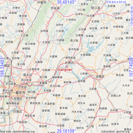
| Upper-left | 30.40145°, | 106.33403° |
| Center: | 29.79313°, | 107.03715° |
| Lower-right: | 29.18109°, | 107.74028° |
| Map W x H: | 135.7×135.7 km | = 84.3×84.3mi |
| max Lat: | 53.31946° ⇑56.4% North |
| Jiangnan: | 29.79313° |
| min Lat: | ⇓43.6% South 18.22056° |
| min Long | Jiangnan | max Long |
| 75.07348° | 107.03715° | 134.28917° |
| W 16.4%⇐ | ⇒83.6% E |
Elevation
Elevation of Jiangnan is 207 m = 679 ft, and this is 277.8 m = 911 ft below average elevation for this country.
| Max E: |
5622 m = 18445 ft | 45% |
| Avg. | 484.8 m = 1591 ft | |
| Jiangnan | 207 m = 679 ft | |
Min E: |
-3 m = -10 ft | 55% |
See also: China elevation on elevation.city.
Geographical zone
Jiangnan is located in North temperate zone (between Tropic of Cancer and the Arctic Circle). Distance of this Northern Tropic circle is 706.8 km =439.2 mi to South.| Distance of | km | miles | from Jiangnan |
|---|---|---|---|
| North Pole | 6694.4 | 4159.7 | to North |
| Arctic Circle | 4088.5 | 2540.5 | to North |
| Tropic Cancer | 706.8 | 439.2 | to South |
| Equator | 3312.7 | 2058.4 | to South |


Nearby cities:
15 places around Jiangnan: (largest is in red/bold)
• Bake
12 km =7.5 mi,  353°
353°
• Dandu
11.6 km =7.2 mi,  65°
65°
• Dasheng
17.3 km =10.7 mi,  308°
308°
• Duzhou
10.3 km =6.4 mi,  22°
22°
• Fengcheng
4.7 km =2.9 mi,  33°
33°
• Lianghui
18.6 km =11.6 mi,  160°
160°
• Luoqi
13.3 km =8.3 mi,  228°
228°
• Maliuzui
14.3 km =8.9 mi,  218°
218°
• Shihe
7 km =4.3 mi,  169°
169°
• Shituo
12.8 km =8 mi,  132°
132°
• Tongjing
19.8 km =12.3 mi,  290°
290°
• Xinmiao
15.4 km =9.6 mi,  175°
175°
• Xinshi
19.6 km =12.2 mi, 19°
• Yihe
18.6 km =11.6 mi,  109°
109°
• Zhen’an
13.7 km =8.5 mi, 127°
Sources, notices
• [Note1] Compared only with cities in China existing in our database
• [Src1] Map data: © OpenStreetMap contributors (CC-BY-SA)
• [Src2] Other city data from geonames.org with taken over terms of usage.
• [Src3] Geographical zone / Annual Mean Temperature by Robert A. Rohde @ Wikipedia
