Caoshi geodata
Caoshi (Hubei) is a seat of a fourth-order administrative division; located in China in Asia/Shanghai (GMT+8) time zone. In our database, there are 1268 cities with bigger population. Compared to other cities in China, 53.1% of cities are located further ↑North; 56.2% of cities are located further →East and 78.3% of cities have higher elevation than Caoshi. Note1


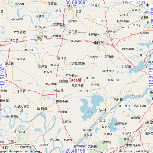
Caoshi GPS coordinates[2]
30° 5' 31.956" North, 113° 12' 53.172" East
| Map corner | latitude | longitude |
|---|---|---|
| Upper-left | 30.69869°, | 112.51165° |
| Center: | 30.09221°, | 113.21477° |
| Lower-right: | 29.48199°, | 113.9179° |
| Map W x H: | 135.3×135.3 km | = 84.1×84.1mi |
| max Lat: | 53.31946° ⇑53.1% North |
| Caoshi: | 30.09221° |
| min Lat: | ⇓46.9% South 18.22056° |
| min Long | Caoshi | max Long |
| 75.07348° | 113.21477° | 134.28917° |
| W 43.8%⇐ | ⇒56.2% E |
Elevation
Elevation of Caoshi is 30 m = 98 ft, and this is 454.8 m = 1492 ft below average elevation for this country.
| Max E: |
5622 m = 18445 ft | 78.3% |
| Avg. | 484.8 m = 1591 ft | |
| Caoshi | 30 m = 98 ft | |
Min E: |
-3 m = -10 ft | 21.7% |
See also: China elevation on elevation.city.
Geographical zone
Caoshi is located in North temperate zone (between Tropic of Cancer and the Arctic Circle). Distance of this Northern Tropic circle is 740 km =459.8 mi to South.| Distance of | km | miles | from Caoshi |
|---|---|---|---|
| North Pole | 6661.1 | 4139 | to North |
| Arctic Circle | 4055.2 | 2519.8 | to North |
| Tropic Cancer | 740 | 459.8 | to South |
| Equator | 3345.9 | 2079 | to South |


Nearby cities:
15 places around Caoshi: (largest is in red/bold)
• Chenchang
21.1 km =13.1 mi,  321°
321°
• Daijiachang
6.8 km =4.2 mi,  173°
173°
• Fengkou
11.5 km =7.1 mi,  95°
95°
• Fenyan
19.9 km =12.4 mi,  232°
232°
• Fuchang
6 km =3.7 mi,  279°
279°
• Gongchang
12.2 km =7.6 mi,  249°
249°
• Guohe
18.6 km =11.6 mi,  23°
23°
• Mianchenghuizu
11.9 km =7.4 mi,  4°
4°
• Qujiawan
14.1 km =8.8 mi,  190°
190°
• Shakou
13.9 km =8.6 mi,  150°
150°
• Tonghaikou
13.2 km =8.2 mi,  332°
332°
• Wangshi
10.7 km =6.6 mi, 281°
• Wanquan
17.9 km =11.1 mi,  113°
113°
• Xingfu
22 km =13.7 mi,  298°
298°
• Zhouhe
21.9 km =13.6 mi,  179°
179°
Sources, notices
• [Note1] Compared only with cities in China existing in our database
• [Src1] Map data: © OpenStreetMap contributors (CC-BY-SA)
• [Src2] Other city data from geonames.org with taken over terms of usage.
• [Src3] Geographical zone / Annual Mean Temperature by Robert A. Rohde @ Wikipedia
