Fenyan geodata
Fenyan (Hubei) is a seat of a fourth-order administrative division; located in China in Asia/Shanghai (GMT+8) time zone. In our database, there are 1268 cities with bigger population. Compared to other cities in China, 54.2% of cities are located further ↑North; 57.3% of cities are located further →East and 77.2% of cities have higher elevation than Fenyan. Note1


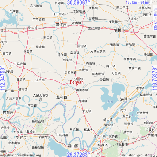
Fenyan GPS coordinates[2]
29° 59' 0.672" North, 113° 3' 2.34" East
| Map corner | latitude | longitude |
|---|---|---|
| Upper-left | 30.59067°, | 112.34753° |
| Center: | 29.98352°, | 113.05065° |
| Lower-right: | 29.37263°, | 113.75378° |
| Map W x H: | 135.4×135.4 km | = 84.1×84.1mi |
| max Lat: | 53.31946° ⇑54.2% North |
| Fenyan: | 29.98352° |
| min Lat: | ⇓45.8% South 18.22056° |
| min Long | Fenyan | max Long |
| 75.07348° | 113.05065° | 134.28917° |
| W 42.7%⇐ | ⇒57.3% E |
Elevation
Elevation of Fenyan is 32 m = 105 ft, and this is 452.8 m = 1486 ft below average elevation for this country.
| Max E: |
5622 m = 18445 ft | 77.2% |
| Avg. | 484.8 m = 1591 ft | |
| Fenyan | 32 m = 105 ft | |
Min E: |
-3 m = -10 ft | 22.8% |
See also: China elevation on elevation.city.
Geographical zone
Fenyan is located in North temperate zone (between Tropic of Cancer and the Arctic Circle). Distance of this Northern Tropic circle is 727.9 km =452.3 mi to South.| Distance of | km | miles | from Fenyan |
|---|---|---|---|
| North Pole | 6673.2 | 4146.5 | to North |
| Arctic Circle | 4067.3 | 2527.3 | to North |
| Tropic Cancer | 727.9 | 452.3 | to South |
| Equator | 3333.9 | 2071.6 | to South |


Nearby cities:
15 places around Fenyan: (largest is in red/bold)
• Bianhe
18.8 km =11.7 mi,  170°
170°
• Caoshi
19.9 km =12.4 mi,  52°
52°
• Daijiachang
17.4 km =10.8 mi,  72°
72°
• Fuchang
16.4 km =10.2 mi,  37°
37°
• Futiansi
9.8 km =6.1 mi,  163°
163°
• Gongchang
9 km =5.6 mi,  28°
28°
• Hongcheng
22 km =13.7 mi,  224°
224°
• Huangxiekou
19.9 km =12.4 mi,  286°
286°
• Maoshi
10.3 km =6.4 mi,  203°
203°
• Qujiawan
13.4 km =8.3 mi,  97°
97°
• Shangchewan
20.7 km =12.9 mi,  191°
191°
• Wangshi
15.2 km =9.4 mi,  20°
20°
• Xingou
19 km =11.8 mi,  330°
330°
• Zhouhe
18.6 km =11.6 mi,  121°
121°
• Zhoulaozui
8.8 km =5.5 mi,  309°
309°
Sources, notices
• [Note1] Compared only with cities in China existing in our database
• [Src1] Map data: © OpenStreetMap contributors (CC-BY-SA)
• [Src2] Other city data from geonames.org with taken over terms of usage.
• [Src3] Geographical zone / Annual Mean Temperature by Robert A. Rohde @ Wikipedia
