Xing’an geodata
Xing’an (Hebei) is a seat of a fourth-order administrative division; located in China in Asia/Shanghai (GMT+8) time zone. In our database, there are 1268 cities with bigger population. Compared to other cities in China, 80.9% of cities are located further ↓South; 53.8% of cities are located further ←West and 70% of cities have higher elevation than Xing’an. Note1


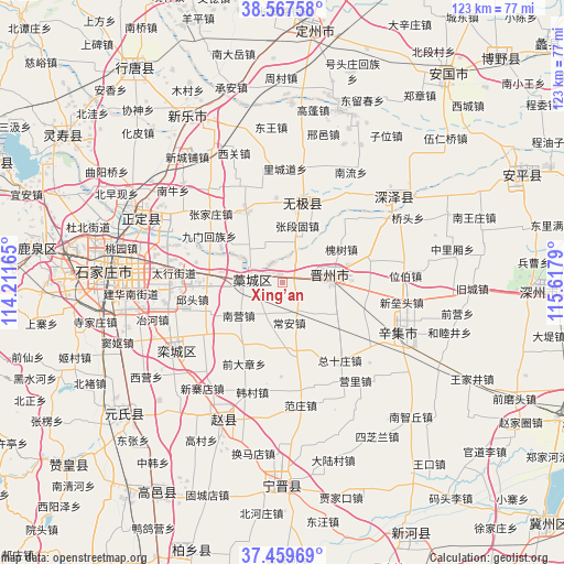
Xing’an GPS coordinates[2]
38° 0' 56.628" North, 114° 54' 53.172" East
| Map corner | latitude | longitude |
|---|---|---|
| Upper-left | 38.56758°, | 114.21165° |
| Center: | 38.01573°, | 114.91477° |
| Lower-right: | 37.45969°, | 115.6179° |
| Map W x H: | 123.2×123.2 km | = 76.6×76.6mi |
| max Lat: | 53.31946° ⇑19.1% North |
| Xing’an: | 38.01573° |
| min Lat: | ⇓80.9% South 18.22056° |
| min Long | Xing’an | max Long |
| 75.07348° | 114.91477° | 134.28917° |
| W 53.8%⇐ | ⇒46.2% E |
Elevation
Elevation of Xing’an is 52 m = 171 ft, and this is 432.8 m = 1420 ft below average elevation for this country.
| Max E: |
5622 m = 18445 ft | 70% |
| Avg. | 484.8 m = 1591 ft | |
| Xing’an | 52 m = 171 ft | |
Min E: |
-3 m = -10 ft | 30% |
See also: China elevation on elevation.city.
Geographical zone
Xing’an is located in North temperate zone (between Tropic of Cancer and the Arctic Circle). Distance of this Northern Tropic circle is 1621 km =1007.2 mi to South.| Distance of | km | miles | from Xing’an |
|---|---|---|---|
| North Pole | 5780.1 | 3591.6 | to North |
| Arctic Circle | 3174.2 | 1972.4 | to North |
| Tropic Cancer | 1621 | 1007.2 | to South |
| Equator | 4227 | 2626.5 | to South |


Nearby cities:
15 places around Xing’an: (largest is in red/bold)
• Beile
22.6 km =14 mi,  266°
266°
• Beisu
18.1 km =11.2 mi,  328°
328°
• Donghoufang
18.6 km =11.6 mi,  355°
355°
• Gangshang
20.1 km =12.5 mi,  279°
279°
• Guozhuang
22.2 km =13.8 mi,  348°
348°
• Haozhuang
9.5 km =5.9 mi,  317°
317°
• Jiumen
19.1 km =11.9 mi,  302°
302°
• Lichengdao
24.4 km =15.2 mi,  1°
1°
• Nancun
24.9 km =15.5 mi, 281°
• Nandong
16.8 km =10.4 mi,  305°
305°
• Nanmeng
24.4 km =15.2 mi, 330°
• Songying
25.3 km =15.7 mi, 272°
• Zhangduangu
13.2 km =8.2 mi,  10°
10°
• Zhangjiazhuang
23.6 km =14.7 mi, 318°
• Zhoutou
14.6 km =9.1 mi,  142°
142°
Sources, notices
• [Note1] Compared only with cities in China existing in our database
• [Src1] Map data: © OpenStreetMap contributors (CC-BY-SA)
• [Src2] Other city data from geonames.org with taken over terms of usage.
• [Src3] Geographical zone / Annual Mean Temperature by Robert A. Rohde @ Wikipedia
