Songying geodata
Songying (Hebei) is a seat of a fourth-order administrative division; located in China in Asia/Shanghai (GMT+8) time zone. In our database, there are 1268 cities with bigger population. Compared to other cities in China, 80.9% of cities are located further ↓South; 52.2% of cities are located further ←West and 66.4% of cities have higher elevation than Songying. Note1


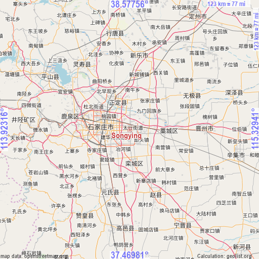
Songying GPS coordinates[2]
38° 1' 32.808" North, 114° 37' 34.608" East
| Map corner | latitude | longitude |
|---|---|---|
| Upper-left | 38.57756°, | 113.92316° |
| Center: | 38.02578°, | 114.62628° |
| Lower-right: | 37.46981°, | 115.32941° |
| Map W x H: | 123.2×123.2 km | = 76.6×76.6mi |
| max Lat: | 53.31946° ⇑19.1% North |
| Songying: | 38.02578° |
| min Lat: | ⇓80.9% South 18.22056° |
| min Long | Songying | max Long |
| 75.07348° | 114.62628° | 134.28917° |
| W 52.2%⇐ | ⇒47.8% E |
Elevation
Elevation of Songying is 67 m = 220 ft, and this is 417.8 m = 1371 ft below average elevation for this country.
| Max E: |
5622 m = 18445 ft | 66.4% |
| Avg. | 484.8 m = 1591 ft | |
| Songying | 67 m = 220 ft | |
Min E: |
-3 m = -10 ft | 33.6% |
See also: China elevation on elevation.city.
Geographical zone
Songying is located in North temperate zone (between Tropic of Cancer and the Arctic Circle). Distance of this Northern Tropic circle is 1622.2 km =1008 mi to South.| Distance of | km | miles | from Songying |
|---|---|---|---|
| North Pole | 5779 | 3590.9 | to North |
| Arctic Circle | 3173.1 | 1971.7 | to North |
| Tropic Cancer | 1622.2 | 1008 | to South |
| Equator | 4228.1 | 2627.2 | to South |


Nearby cities:
15 places around Songying: (largest is in red/bold)
• Beile
3.6 km =2.2 mi,  130°
130°
• Ershilipu
4.6 km =2.9 mi,  279°
279°
• Gangshang
5.9 km =3.7 mi,  67°
67°
• Jiumen
12.9 km =8 mi,  45°
45°
• Liuying
18.1 km =11.2 mi, 279°
• Luancheng
16.5 km =10.3 mi,  172°
172°
• Nancun
4.1 km =2.5 mi,  12°
12°
• Nandong
14.4 km =8.9 mi, 53°
• Nanniu
19.1 km =11.9 mi,  3°
3°
• Shijiazhuang
13 km =8.1 mi, 277°
• Taoyuan
11.4 km =7.1 mi,  303°
303°
• Xizhaotong
5.7 km =3.5 mi,  333°
333°
• Zhangjiazhuang
19.2 km =11.9 mi,  30°
30°
• Zhaolingpu
16.3 km =10.1 mi, 299°
• Zhufutun
14.8 km =9.2 mi, 6°
Sources, notices
• [Note1] Compared only with cities in China existing in our database
• [Src1] Map data: © OpenStreetMap contributors (CC-BY-SA)
• [Src2] Other city data from geonames.org with taken over terms of usage.
• [Src3] Geographical zone / Annual Mean Temperature by Robert A. Rohde @ Wikipedia
