Hezhai geodata
Hezhai (Shaanxi) is a seat of a fourth-order administrative division; located in China in Asia/Shanghai (GMT+8) time zone. In our database, there are 1268 cities with bigger population. Compared to other cities in China, 72.8% of cities are located further ↓South; 74.8% of cities are located further →East and 67% of cities have lower elevation than Hezhai. Note1


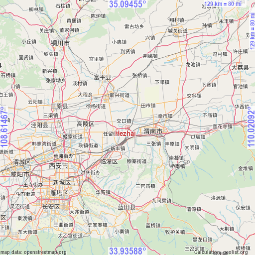
Hezhai GPS coordinates[2]
34° 31' 2.028" North, 109° 19' 4.044" East
| Map corner | latitude | longitude |
|---|---|---|
| Upper-left | 35.09455°, | 108.61467° |
| Center: | 34.51723°, | 109.31779° |
| Lower-right: | 33.93588°, | 110.02092° |
| Map W x H: | 128.8×128.8 km | = 80×80mi |
| max Lat: | 53.31946° ⇑27.2% North |
| Hezhai: | 34.51723° |
| min Lat: | ⇓72.8% South 18.22056° |
| min Long | Hezhai | max Long |
| 75.07348° | 109.31779° | 134.28917° |
| W 25.2%⇐ | ⇒74.8% E |
Elevation
Elevation of Hezhai is 359 m = 1178 ft, and this is 125.8 m = 413 ft below average elevation for this country.
| Max E: |
5622 m = 18445 ft | 33% |
| Avg. | 484.8 m = 1591 ft | |
| Hezhai | 359 m = 1178 ft | |
Min E: |
-3 m = -10 ft | 67% |
See also: China elevation on elevation.city.
Geographical zone
Hezhai is located in North temperate zone (between Tropic of Cancer and the Arctic Circle). Distance of this Northern Tropic circle is 1232 km =765.5 mi to South.| Distance of | km | miles | from Hezhai |
|---|---|---|---|
| North Pole | 6169.1 | 3833.3 | to North |
| Arctic Circle | 3563.2 | 2214.1 | to North |
| Tropic Cancer | 1232 | 765.5 | to South |
| Equator | 3838 | 2384.8 | to South |


Nearby cities:
15 places around Hezhai: (largest is in red/bold)
• Beitun
13.7 km =8.5 mi,  324°
324°
• Daiwang
13.6 km =8.5 mi,  189°
189°
• Jiaokou
4.1 km =2.5 mi,  332°
332°
• Lingkou
5.9 km =3.7 mi,  138°
138°
• Liyang
12.5 km =7.8 mi,  307°
307°
• Ma’e
14.1 km =8.8 mi,  154°
154°
• Renliu
8.8 km =5.5 mi,  250°
250°
• Sanzhang
15.3 km =9.5 mi,  120°
120°
• Tianshi
15.4 km =9.6 mi,  40°
40°
• Wutun
13.6 km =8.5 mi,  351°
351°
• Xiangqiao
11.8 km =7.3 mi,  22°
22°
• Xinfeng
11.2 km =7 mi,  206°
206°
• Xinshi
12.8 km =8 mi,  280°
280°
• Youhuai
7.7 km =4.8 mi,  53°
53°
• Yujin
6.7 km =4.2 mi,  267°
267°
Sources, notices
• [Note1] Compared only with cities in China existing in our database
• [Src1] Map data: © OpenStreetMap contributors (CC-BY-SA)
• [Src2] Other city data from geonames.org with taken over terms of usage.
• [Src3] Geographical zone / Annual Mean Temperature by Robert A. Rohde @ Wikipedia
