Xinchong geodata
Xinchong (Hubei) is a seat of a fourth-order administrative division; located in China in Asia/Shanghai (GMT+8) time zone. In our database, there are 1268 cities with bigger population. Compared to other cities in China, 52.7% of cities are located further ↓South; 53.2% of cities are located further ←West and 74.4% of cities have higher elevation than Xinchong. Note1


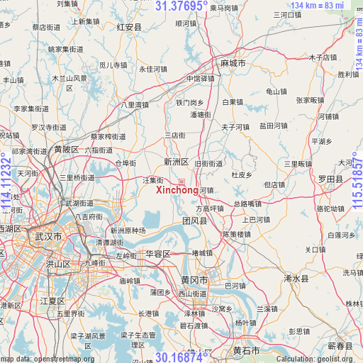
Xinchong GPS coordinates[2]
30° 46' 29.064" North, 114° 48' 55.584" East
| Map corner | latitude | longitude |
|---|---|---|
| Upper-left | 31.37695°, | 114.11232° |
| Center: | 30.77474°, | 114.81544° |
| Lower-right: | 30.16874°, | 115.51857° |
| Map W x H: | 134.3×134.3 km | = 83.5×83.5mi |
| max Lat: | 53.31946° ⇑47.3% North |
| Xinchong: | 30.77474° |
| min Lat: | ⇓52.7% South 18.22056° |
| min Long | Xinchong | max Long |
| 75.07348° | 114.81544° | 134.28917° |
| W 53.2%⇐ | ⇒46.8% E |
Elevation
Elevation of Xinchong is 38 m = 125 ft, and this is 446.8 m = 1466 ft below average elevation for this country.
| Max E: |
5622 m = 18445 ft | 74.4% |
| Avg. | 484.8 m = 1591 ft | |
| Xinchong | 38 m = 125 ft | |
Min E: |
-3 m = -10 ft | 25.6% |
See also: China elevation on elevation.city.
Geographical zone
Xinchong is located in North temperate zone (between Tropic of Cancer and the Arctic Circle). Distance of this Northern Tropic circle is 815.9 km =507 mi to South.| Distance of | km | miles | from Xinchong |
|---|---|---|---|
| North Pole | 6585.2 | 4091.9 | to North |
| Arctic Circle | 3979.3 | 2472.6 | to North |
| Tropic Cancer | 815.9 | 507 | to South |
| Equator | 3421.8 | 2126.2 | to South |


Nearby cities:
15 places around Xinchong: (largest is in red/bold)
• Cangbu
22.3 km =13.9 mi,  287°
287°
• Dupi
22.6 km =14 mi,  84°
84°
• Fanggaoping
14.6 km =9.1 mi,  132°
132°
• Huilongshan
23.3 km =14.5 mi,  138°
138°
• Jiujie
12.1 km =7.5 mi,  56°
56°
• Liji
18 km =11.2 mi,  307°
307°
• Linshanhe
7.5 km =4.7 mi,  118°
118°
• Macaomiao
23.3 km =14.5 mi, 124°
• Sandian
17.5 km =10.9 mi,  352°
352°
• Tuanfeng
11.8 km =7.3 mi, 125°
• Wangji
10.7 km =6.6 mi,  272°
272°
• Xinzhou
10.3 km =6.4 mi, 351°
• Xugu
24.4 km =15.2 mi,  36°
36°
• Zhangduhu
11.5 km =7.1 mi,  192°
192°
• Zongluzui
25 km =15.5 mi,  110°
110°
Sources, notices
• [Note1] Compared only with cities in China existing in our database
• [Src1] Map data: © OpenStreetMap contributors (CC-BY-SA)
• [Src2] Other city data from geonames.org with taken over terms of usage.
• [Src3] Geographical zone / Annual Mean Temperature by Robert A. Rohde @ Wikipedia
