Cangbu geodata
Cangbu (Hubei) is a seat of a fourth-order administrative division; located in China in Asia/Shanghai (GMT+8) time zone. In our database, there are 1268 cities with bigger population. Compared to other cities in China, 53.2% of cities are located further ↓South; 52% of cities are located further ←West and 80.8% of cities have higher elevation than Cangbu. Note1


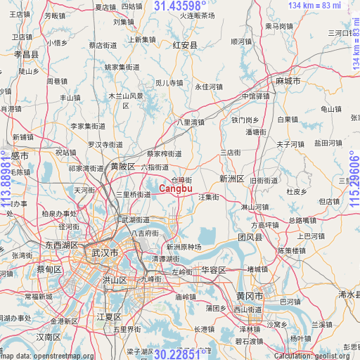
Cangbu GPS coordinates[2]
30° 50' 2.904" North, 114° 35' 34.548" East
| Map corner | latitude | longitude |
|---|---|---|
| Upper-left | 31.43598°, | 113.88981° |
| Center: | 30.83414°, | 114.59293° |
| Lower-right: | 30.22851°, | 115.29606° |
| Map W x H: | 134.3×134.3 km | = 83.5×83.5mi |
| max Lat: | 53.31946° ⇑46.8% North |
| Cangbu: | 30.83414° |
| min Lat: | ⇓53.2% South 18.22056° |
| min Long | Cangbu | max Long |
| 75.07348° | 114.59293° | 134.28917° |
| W 52%⇐ | ⇒48% E |
Elevation
Elevation of Cangbu is 25 m = 82 ft, and this is 459.8 m = 1509 ft below average elevation for this country.
| Max E: |
5622 m = 18445 ft | 80.8% |
| Avg. | 484.8 m = 1591 ft | |
| Cangbu | 25 m = 82 ft | |
Min E: |
-3 m = -10 ft | 19.2% |
See also: China elevation on elevation.city.
Geographical zone
Cangbu is located in North temperate zone (between Tropic of Cancer and the Arctic Circle). Distance of this Northern Tropic circle is 822.5 km =511.1 mi to South.| Distance of | km | miles | from Cangbu |
|---|---|---|---|
| North Pole | 6578.6 | 4087.8 | to North |
| Arctic Circle | 3972.7 | 2468.5 | to North |
| Tropic Cancer | 822.5 | 511.1 | to South |
| Equator | 3428.4 | 2130.3 | to South |


Nearby cities:
15 places around Cangbu: (largest is in red/bold)
• Caijiazha
11.7 km =7.3 mi,  329°
329°
• Dujiajing
23.2 km =14.4 mi,  214°
214°
• Guanshang
20.1 km =12.5 mi,  190°
190°
• Huangpi
21.3 km =13.2 mi,  285°
285°
• Jiaomingsi
18.2 km =11.3 mi,  251°
251°
• Liji
8.2 km =5.1 mi,  58°
58°
• Liuzhi
10.9 km =6.8 mi,  300°
300°
• Mi’ersi
23.2 km =14.4 mi,  346°
346°
• Qianquan
21.4 km =13.3 mi,  281°
281°
• Sandian
21.8 km =13.5 mi, 60°
• Taipingqiao
15 km =9.3 mi,  17°
17°
• Wangji
12.2 km =7.6 mi,  120°
120°
• Wangjiahe
22.4 km =13.9 mi,  310°
310°
• Xinchong
22.3 km =13.9 mi,  107°
107°
• Xinzhou
20.1 km =12.5 mi,  79°
79°
Sources, notices
• [Note1] Compared only with cities in China existing in our database
• [Src1] Map data: © OpenStreetMap contributors (CC-BY-SA)
• [Src2] Other city data from geonames.org with taken over terms of usage.
• [Src3] Geographical zone / Annual Mean Temperature by Robert A. Rohde @ Wikipedia
