Wangji geodata
Wangji (Hubei) is a seat of a fourth-order administrative division; located in China in Asia/Shanghai (GMT+8) time zone. In our database, there are 1268 cities with bigger population. Compared to other cities in China, 52.8% of cities are located further ↓South; 52.6% of cities are located further ←West and 79.3% of cities have higher elevation than Wangji. Note1


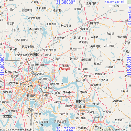
Wangji GPS coordinates[2]
30° 46' 41.52" North, 114° 42' 11.448" East
| Map corner | latitude | longitude |
|---|---|---|
| Upper-left | 31.38039°, | 114.00006° |
| Center: | 30.7782°, | 114.70318° |
| Lower-right: | 30.17222°, | 115.40631° |
| Map W x H: | 134.3×134.3 km | = 83.5×83.5mi |
| max Lat: | 53.31946° ⇑47.2% North |
| Wangji: | 30.7782° |
| min Lat: | ⇓52.8% South 18.22056° |
| min Long | Wangji | max Long |
| 75.07348° | 114.70318° | 134.28917° |
| W 52.6%⇐ | ⇒47.4% E |
Elevation
Elevation of Wangji is 28 m = 92 ft, and this is 456.8 m = 1499 ft below average elevation for this country.
| Max E: |
5622 m = 18445 ft | 79.3% |
| Avg. | 484.8 m = 1591 ft | |
| Wangji | 28 m = 92 ft | |
Min E: |
-3 m = -10 ft | 20.7% |
See also: China elevation on elevation.city.
Geographical zone
Wangji is located in North temperate zone (between Tropic of Cancer and the Arctic Circle). Distance of this Northern Tropic circle is 816.3 km =507.2 mi to South.| Distance of | km | miles | from Wangji |
|---|---|---|---|
| North Pole | 6584.8 | 4091.6 | to North |
| Arctic Circle | 3979 | 2472.4 | to North |
| Tropic Cancer | 816.3 | 507.2 | to South |
| Equator | 3422.2 | 2126.5 | to South |


Nearby cities:
15 places around Wangji: (largest is in red/bold)
• Caijiazha
23.2 km =14.4 mi,  314°
314°
• Cangbu
12.2 km =7.6 mi,  300°
300°
• Fanggaoping
23.7 km =14.7 mi,  115°
115°
• Guanshang
19.7 km =12.2 mi,  226°
226°
• Jiujie
21.8 km =13.5 mi,  73°
73°
• Liji
11.1 km =6.9 mi,  341°
341°
• Linshanhe
17.7 km =11 mi,  102°
102°
• Liuzhi
23.1 km =14.4 mi, 300°
• Sandian
19 km =11.8 mi,  26°
26°
• Shuangliu
21.5 km =13.4 mi,  195°
195°
• Taipingqiao
21.3 km =13.2 mi, 343°
• Tuanfeng
21.6 km =13.4 mi,  109°
109°
• Xinchong
10.7 km =6.6 mi,  92°
92°
• Xinzhou
13.5 km =8.4 mi,  43°
43°
• Zhangduhu
14.3 km =8.9 mi,  144°
144°
Sources, notices
• [Note1] Compared only with cities in China existing in our database
• [Src1] Map data: © OpenStreetMap contributors (CC-BY-SA)
• [Src2] Other city data from geonames.org with taken over terms of usage.
• [Src3] Geographical zone / Annual Mean Temperature by Robert A. Rohde @ Wikipedia
