Xinzhou geodata
Xinzhou (Hubei) is a populated place; located in China in Asia/Shanghai (GMT+8) time zone. With population of 78,767 people, there are 541 cities with bigger population in this country. Compared to other cities in China, 53.5% of cities are located further ↓South; 53.1% of cities are located further ←West and 78.8% of cities have higher elevation than Xinzhou. Note1


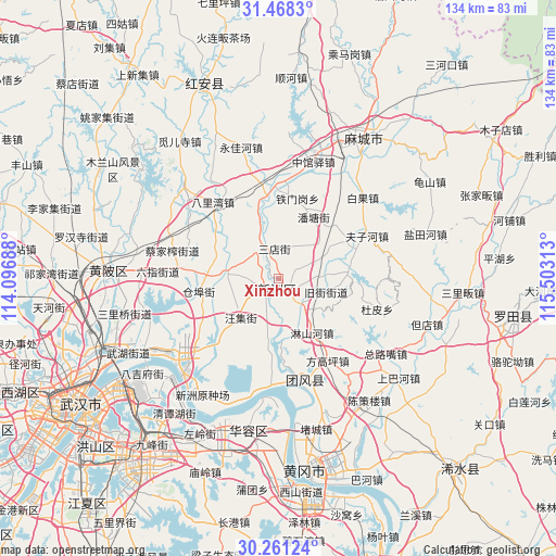
Xinzhou GPS coordinates[2]
30° 52' 0.012" North, 114° 48' 0" East
| Map corner | latitude | longitude |
|---|---|---|
| Upper-left | 31.4683°, | 114.09688° |
| Center: | 30.86667°, | 114.8° |
| Lower-right: | 30.26124°, | 115.50313° |
| Map W x H: | 134.2×134.2 km | = 83.4×83.4mi |
| max Lat: | 53.31946° ⇑46.5% North |
| Xinzhou: | 30.86667° |
| min Lat: | ⇓53.5% South 18.22056° |
| min Long | Xinzhou | max Long |
| 75.07348° | 114.8° | 134.28917° |
| W 53.1%⇐ | ⇒46.9% E |
Elevation
Elevation of Xinzhou is 29 m = 95 ft, and this is 455.8 m = 1495 ft below average elevation for this country.
| Max E: |
5622 m = 18445 ft | 78.8% |
| Avg. | 484.8 m = 1591 ft | |
| Xinzhou | 29 m = 95 ft | |
Min E: |
-3 m = -10 ft | 21.2% |
See also: Xinzhou elevation on elevation.city.
Geographical zone
Xinzhou is located in North temperate zone (between Tropic of Cancer and the Arctic Circle). Distance of this Northern Tropic circle is 826.1 km =513.3 mi to South.| Distance of | km | miles | from Xinzhou |
|---|---|---|---|
| North Pole | 6575 | 4085.5 | to North |
| Arctic Circle | 3969.1 | 2466.3 | to North |
| Tropic Cancer | 826.1 | 513.3 | to South |
| Equator | 3432.1 | 2132.6 | to South |


Nearby cities:
15 places around Xinzhou: (largest is in red/bold)
• Cangbu
20.1 km =12.5 mi,  259°
259°
• Jiujie
12.1 km =7.5 mi,  106°
106°
• Liji
12.8 km =8 mi,  272°
272°
• Linshanhe
16 km =9.9 mi,  149°
149°
• Pantang
16.9 km =10.5 mi,  29°
29°
• Qiting
17.3 km =10.7 mi,  341°
341°
• Sandian
7.2 km =4.5 mi,  353°
353°
• Songbu
21.8 km =13.5 mi,  358°
358°
• Taipingqiao
18.5 km =11.5 mi,  305°
305°
• Tiemengang
19.8 km =12.3 mi,  13°
13°
• Tuanfeng
20.3 km =12.6 mi, 146°
• Wangji
13.5 km =8.4 mi,  223°
223°
• Xinchong
10.3 km =6.4 mi,  171°
171°
• Xugu
18.6 km =11.6 mi,  59°
59°
• Zhangduhu
21.5 km =13.4 mi,  182°
182°
Sources, notices
• [Note1] Compared only with cities in China existing in our database
• [Src1] Map data: © OpenStreetMap contributors (CC-BY-SA)
• [Src2] Other city data from geonames.org with taken over terms of usage.
• [Src3] Geographical zone / Annual Mean Temperature by Robert A. Rohde @ Wikipedia
