Xincai geodata
Xincai (Henan) is a seat of a third-order administrative division; located in China in Asia/Shanghai (GMT+8) time zone. In our database, there are 1268 cities with bigger population. Compared to other cities in China, 65% of cities are located further ↓South; 54.2% of cities are located further ←West and 73.3% of cities have higher elevation than Xincai. Note1


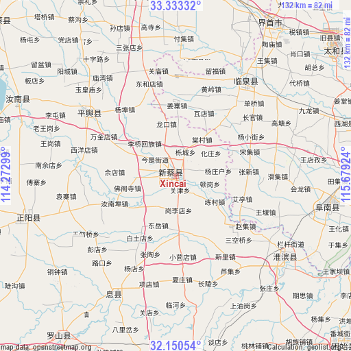
Xincai GPS coordinates[2]
32° 44' 38.004" North, 114° 58' 33.996" East
| Map corner | latitude | longitude |
|---|---|---|
| Upper-left | 33.33332°, | 114.27299° |
| Center: | 32.74389°, | 114.97611° |
| Lower-right: | 32.15054°, | 115.67924° |
| Map W x H: | 131.5×131.5 km | = 81.7×81.7mi |
| max Lat: | 53.31946° ⇑35% North |
| Xincai: | 32.74389° |
| min Lat: | ⇓65% South 18.22056° |
| min Long | Xincai | max Long |
| 75.07348° | 114.97611° | 134.28917° |
| W 54.2%⇐ | ⇒45.8% E |
Elevation
Elevation of Xincai is 41 m = 135 ft, and this is 443.8 m = 1456 ft below average elevation for this country.
| Max E: |
5622 m = 18445 ft | 73.3% |
| Avg. | 484.8 m = 1591 ft | |
| Xincai | 41 m = 135 ft | |
Min E: |
-3 m = -10 ft | 26.7% |
See also: China elevation on elevation.city.
Geographical zone
Xincai is located in North temperate zone (between Tropic of Cancer and the Arctic Circle). Distance of this Northern Tropic circle is 1034.9 km =643.1 mi to South.| Distance of | km | miles | from Xincai |
|---|---|---|---|
| North Pole | 6366.3 | 3955.8 | to North |
| Arctic Circle | 3760.4 | 2336.6 | to North |
| Tropic Cancer | 1034.9 | 643.1 | to South |
| Equator | 3640.8 | 2262.3 | to South |


Nearby cities:
15 places around Xincai: (largest is in red/bold)
• Dingcheng
68.8 km =42.8 mi,  175°
175°
• Dongcheng
75 km =46.6 mi,  7°
7°
• Funan Chengguanzhen
61 km =37.9 mi,  101°
101°
• Fuyang
80.4 km =50 mi,  77°
77°
• Guhuai
40.5 km =25.2 mi,  306°
306°
• Huaibin Chengguanzhen
51.1 km =31.8 mi,  127°
127°
• Huaidian
76.8 km =47.7 mi,  3°
3°
• Huayuan
81.2 km =50.5 mi,  353°
353°
• Jieshou
68 km =42.3 mi,  31°
31°
• Linquan Chengguanzhen
47.9 km =29.8 mi,  37°
37°
• Luoshan Chengguanzhen
74.4 km =46.2 mi,  216°
216°
• Runing
64.7 km =40.2 mi,  296°
296°
• Taihe Chengguanzhen
78.3 km =48.7 mi,  53°
53°
• Xi Xian Chengguanzhen
50.2 km =31.2 mi,  207°
207°
• Zhenyang
57.7 km =35.9 mi,  254°
254°
Sources, notices
• [Note1] Compared only with cities in China existing in our database
• [Src1] Map data: © OpenStreetMap contributors (CC-BY-SA)
• [Src2] Other city data from geonames.org with taken over terms of usage.
• [Src3] Geographical zone / Annual Mean Temperature by Robert A. Rohde @ Wikipedia
