Zhenyang geodata
Zhenyang (Henan) is a seat of a third-order administrative division; located in China in Asia/Shanghai (GMT+8) time zone. In our database, there are 1268 cities with bigger population. Compared to other cities in China, 64.4% of cities are located further ↓South; 50.9% of cities are located further ←West and 63.3% of cities have higher elevation than Zhenyang. Note1


Zhenyang GPS coordinates[2]
32° 36' 12.996" North, 114° 22' 59.016" East
| Map corner | latitude | longitude |
|---|---|---|
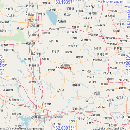
| Upper-left | 33.19397°, | 113.67994° |
| Center: | 32.60361°, | 114.38306° |
| Lower-right: | 32.00933°, | 115.08619° |
| Map W x H: | 131.7×131.7 km | = 81.8×81.8mi |
| max Lat: | 53.31946° ⇑35.6% North |
| Zhenyang: | 32.60361° |
| min Lat: | ⇓64.4% South 18.22056° |
| min Long | Zhenyang | max Long |
| 75.07348° | 114.38306° | 134.28917° |
| W 50.9%⇐ | ⇒49.1% E |
Elevation
Elevation of Zhenyang is 81 m = 266 ft, and this is 403.8 m = 1325 ft below average elevation for this country.
| Max E: |
5622 m = 18445 ft | 63.3% |
| Avg. | 484.8 m = 1591 ft | |
| Zhenyang | 81 m = 266 ft | |
Min E: |
-3 m = -10 ft | 36.7% |
See also: China elevation on elevation.city.
Geographical zone
Zhenyang is located in North temperate zone (between Tropic of Cancer and the Arctic Circle). Distance of this Northern Tropic circle is 1019.3 km =633.4 mi to South.| Distance of | km | miles | from Zhenyang |
|---|---|---|---|
| North Pole | 6381.9 | 3965.5 | to North |
| Arctic Circle | 3776 | 2346.3 | to North |
| Tropic Cancer | 1019.3 | 633.4 | to South |
| Equator | 3625.2 | 2252.6 | to South |


Nearby cities:
15 places around Zhenyang: (largest is in red/bold)
• Guhuai
45.5 km =28.3 mi,  29°
29°
• Laohe
71.7 km =44.6 mi,  299°
299°
• Liuge
57.1 km =35.5 mi,  317°
317°
• Luoshan Chengguanzhen
46.1 km =28.6 mi,  165°
165°
• Minggang
35.3 km =21.9 mi,  242°
242°
• Panlong
40.6 km =25.2 mi, 302°
• Pingqiao
61.6 km =38.3 mi,  203°
203°
• Quyang
70.5 km =43.8 mi,  328°
328°
• Runing
44.3 km =27.5 mi,  356°
356°
• Xi Xian Chengguanzhen
43.5 km =27 mi,  131°
131°
• Xiaolin
69.8 km =43.4 mi, 242°
• Xincai
57.7 km =35.9 mi,  74°
74°
• Xinyang
61.2 km =38 mi,  209°
209°
• Zhumadian
53.3 km =33.1 mi, 321°
• Zhushi
68.7 km =42.7 mi, 317°
Sources, notices
• [Note1] Compared only with cities in China existing in our database
• [Src1] Map data: © OpenStreetMap contributors (CC-BY-SA)
• [Src2] Other city data from geonames.org with taken over terms of usage.
• [Src3] Geographical zone / Annual Mean Temperature by Robert A. Rohde @ Wikipedia
