Jieshou geodata
Jieshou (Anhui) is a populated place; located in China in Asia/Shanghai (GMT+8) time zone. With population of 141,993 people, there are 313 cities with bigger population in this country. Compared to other cities in China, 67.2% of cities are located further ↓South; 56.2% of cities are located further ←West and 73% of cities have higher elevation than Jieshou. Note1


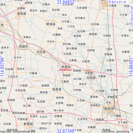
Jieshou GPS coordinates[2]
33° 15' 48.168" North, 115° 21' 39.888" East
| Map corner | latitude | longitude |
|---|---|---|
| Upper-left | 33.84932°, | 114.65796° |
| Center: | 33.26338°, | 115.36108° |
| Lower-right: | 32.67348°, | 116.06421° |
| Map W x H: | 130.7×130.7 km | = 81.2×81.2mi |
| max Lat: | 53.31946° ⇑32.8% North |
| Jieshou: | 33.26338° |
| min Lat: | ⇓67.2% South 18.22056° |
| min Long | Jieshou | max Long |
| 75.07348° | 115.36108° | 134.28917° |
| W 56.2%⇐ | ⇒43.8% E |
Elevation
Elevation of Jieshou is 42 m = 138 ft, and this is 442.8 m = 1453 ft below average elevation for this country.
| Max E: |
5622 m = 18445 ft | 73% |
| Avg. | 484.8 m = 1591 ft | |
| Jieshou | 42 m = 138 ft | |
Min E: |
-3 m = -10 ft | 27% |
See also: Jieshou elevation on elevation.city.
Geographical zone
Jieshou is located in North temperate zone (between Tropic of Cancer and the Arctic Circle). Distance of this Northern Tropic circle is 1092.6 km =678.9 mi to South.| Distance of | km | miles | from Jieshou |
|---|---|---|---|
| North Pole | 6308.5 | 3919.9 | to North |
| Arctic Circle | 3702.6 | 2300.7 | to North |
| Tropic Cancer | 1092.6 | 678.9 | to South |
| Equator | 3698.5 | 2298.1 | to South |


Nearby cities:
15 places around Jieshou: (largest is in red/bold)
• Bozhou
78.1 km =48.5 mi,  29°
29°
• Dongcheng
30.8 km =19.1 mi,  302°
302°
• Funan Chengguanzhen
73.6 km =45.7 mi,  161°
161°
• Fuyang
58.6 km =36.4 mi,  133°
133°
• Guhuai
76.4 km =47.5 mi,  243°
243°
• Huaidian
35.8 km =22.2 mi, 301°
• Huaiyang Chengguanzhen
68.5 km =42.6 mi,  319°
319°
• Huayuan
50.7 km =31.5 mi, 296°
• Jishui
52.4 km =32.6 mi,  3°
3°
• Linquan Chengguanzhen
20.9 km =13 mi,  198°
198°
• Taihe Chengguanzhen
28.9 km =18 mi,  112°
112°
• Xiguan
67.8 km =42.1 mi,  8°
8°
• Xincai
68 km =42.3 mi,  211°
211°
• Xincheng
44.3 km =27.5 mi,  338°
338°
• Xincheng
77.3 km =48 mi,  293°
293°
Sources, notices
• [Note1] Compared only with cities in China existing in our database
• [Src1] Map data: © OpenStreetMap contributors (CC-BY-SA)
• [Src2] Other city data from geonames.org with taken over terms of usage.
• [Src3] Geographical zone / Annual Mean Temperature by Robert A. Rohde @ Wikipedia
