Xieshen geodata
Xieshen (Henan) is a seat of a fourth-order administrative division; located in China in Asia/Shanghai (GMT+8) time zone. In our database, there are 1268 cities with bigger population. Compared to other cities in China, 81.5% of cities are located further ↓South; 51.9% of cities are located further ←West and 60.6% of cities have higher elevation than Xieshen. Note1


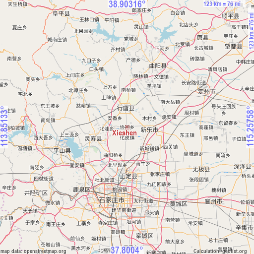
Xieshen GPS coordinates[2]
38° 21' 13.968" North, 114° 33' 16.02" East
| Map corner | latitude | longitude |
|---|---|---|
| Upper-left | 38.90316°, | 113.85133° |
| Center: | 38.35388°, | 114.55445° |
| Lower-right: | 37.8004°, | 115.25758° |
| Map W x H: | 122.6×122.6 km | = 76.2×76.2mi |
| max Lat: | 53.31946° ⇑18.5% North |
| Xieshen: | 38.35388° |
| min Lat: | ⇓81.5% South 18.22056° |
| min Long | Xieshen | max Long |
| 75.07348° | 114.55445° | 134.28917° |
| W 51.9%⇐ | ⇒48.1% E |
Elevation
Elevation of Xieshen is 95 m = 312 ft, and this is 389.8 m = 1279 ft below average elevation for this country.
| Max E: |
5622 m = 18445 ft | 60.6% |
| Avg. | 484.8 m = 1591 ft | |
| Xieshen | 95 m = 312 ft | |
Min E: |
-3 m = -10 ft | 39.4% |
See also: China elevation on elevation.city.
Geographical zone
Xieshen is located in North temperate zone (between Tropic of Cancer and the Arctic Circle). Distance of this Northern Tropic circle is 1658.6 km =1030.6 mi to South.| Distance of | km | miles | from Xieshen |
|---|---|---|---|
| North Pole | 5742.5 | 3568.2 | to North |
| Arctic Circle | 3136.6 | 1949 | to North |
| Tropic Cancer | 1658.6 | 1030.6 | to South |
| Equator | 4264.6 | 2649.9 | to South |


Nearby cities:
15 places around Xieshen: (largest is in red/bold)
• Anxiang
3.5 km =2.2 mi,  339°
339°
• Beiwa
9.8 km =6.1 mi,  267°
267°
• Beizaoxian
13.9 km =8.6 mi,  191°
191°
• Diying
13.4 km =8.3 mi,  312°
312°
• Duyanggang
11.3 km =7 mi,  14°
14°
• Huapi
4.7 km =2.9 mi,  177°
177°
• Mucun
12.8 km =8 mi,  61°
61°
• Nanlou
9.5 km =5.9 mi, 184°
• Nanzhai
14.3 km =8.9 mi,  277°
277°
• Quyangqiao
14.6 km =9.1 mi,  207°
207°
• Sanshengyuan
13.4 km =8.3 mi,  234°
234°
• Shitong
9.5 km =5.9 mi,  331°
331°
• Xinchengpu
14.8 km =9.2 mi,  130°
130°
• Xipingle
11.7 km =7.3 mi,  140°
140°
• Zhili
5.5 km =3.4 mi,  22°
22°
Sources, notices
• [Note1] Compared only with cities in China existing in our database
• [Src1] Map data: © OpenStreetMap contributors (CC-BY-SA)
• [Src2] Other city data from geonames.org with taken over terms of usage.
• [Src3] Geographical zone / Annual Mean Temperature by Robert A. Rohde @ Wikipedia
