Xiashuitou geodata
Xiashuitou (Shanxi) is a seat of a fourth-order administrative division; located in China in Asia/Shanghai (GMT+8) time zone. In our database, there are 1268 cities with bigger population. Compared to other cities in China, 84.8% of cities are located further ↓South; 62.3% of cities are located further →East and 90.5% of cities have lower elevation than Xiashuitou. Note1


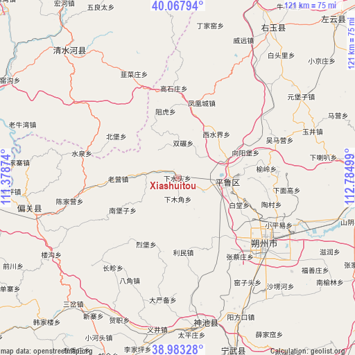
Xiashuitou GPS coordinates[2]
39° 31' 39.828" North, 112° 4' 54.696" East
| Map corner | latitude | longitude |
|---|---|---|
| Upper-left | 40.06794°, | 111.37874° |
| Center: | 39.52773°, | 112.08186° |
| Lower-right: | 38.98328°, | 112.78499° |
| Map W x H: | 120.6×120.6 km | = 74.9×74.9mi |
| max Lat: | 53.31946° ⇑15.2% North |
| Xiashuitou: | 39.52773° |
| min Lat: | ⇓84.8% South 18.22056° |
| min Long | Xiashuitou | max Long |
| 75.07348° | 112.08186° | 134.28917° |
| W 37.7%⇐ | ⇒62.3% E |
Elevation
Elevation of Xiashuitou is 1408 m = 4619 ft, and this is 923.2 m = 3029 ft above average elevation for this country.
| Max E: |
5622 m = 18445 ft | 9.5% |
| Xiashuitou | 1408 m 4619 ft | |
| Avg. | 484.8 m = 1591 ft | |
Min E: |
-3 m = -10 ft | 90.5% |
See also: China elevation on elevation.city.
Geographical zone
Xiashuitou is located in North temperate zone (between Tropic of Cancer and the Arctic Circle). Distance of this Northern Tropic circle is 1789.2 km =1111.8 mi to South.| Distance of | km | miles | from Xiashuitou |
|---|---|---|---|
| North Pole | 5612 | 3487.1 | to North |
| Arctic Circle | 3006.1 | 1867.9 | to North |
| Tropic Cancer | 1789.2 | 1111.8 | to South |
| Equator | 4395.1 | 2731 | to South |


Nearby cities:
15 places around Xiashuitou: (largest is in red/bold)
• Baitang
22.9 km =14.2 mi,  113°
113°
• Beibao
25 km =15.5 mi,  302°
302°
• Fenghuangcheng
26.8 km =16.7 mi,  17°
17°
• Hougaoshizhuang
33.3 km =20.7 mi,  359°
359°
• Jingping
17.3 km =10.7 mi,  92°
92°
• Liebu
24.9 km =15.5 mi,  205°
205°
• Limin
24.7 km =15.3 mi,  172°
172°
• Shuangnian
12.1 km =7.5 mi,  7°
7°
• Taocun
33 km =20.5 mi, 105°
• Xiamujiao
7.1 km =4.4 mi,  180°
180°
• Xiangyangpu
24.7 km =15.3 mi,  69°
69°
• Xiatuanpu
31.4 km =19.5 mi,  126°
126°
• Xishuijie
19.9 km =12.4 mi,  40°
40°
• Yuling
30 km =18.6 mi,  84°
84°
• Zuhu
23.1 km =14.4 mi,  349°
349°
Sources, notices
• [Note1] Compared only with cities in China existing in our database
• [Src1] Map data: © OpenStreetMap contributors (CC-BY-SA)
• [Src2] Other city data from geonames.org with taken over terms of usage.
• [Src3] Geographical zone / Annual Mean Temperature by Robert A. Rohde @ Wikipedia
