Shangqiao geodata
Shangqiao (Henan) is a seat of a fourth-order administrative division; located in China in Asia/Shanghai (GMT+8) time zone. In our database, there are 1268 cities with bigger population. Compared to other cities in China, 68.8% of cities are located further ↓South; 51.7% of cities are located further →East and 67.4% of cities have higher elevation than Shangqiao. Note1


Shangqiao GPS coordinates[2]
33° 42' 21.528" North, 113° 57' 24.012" East
| Map corner | latitude | longitude |
|---|---|---|
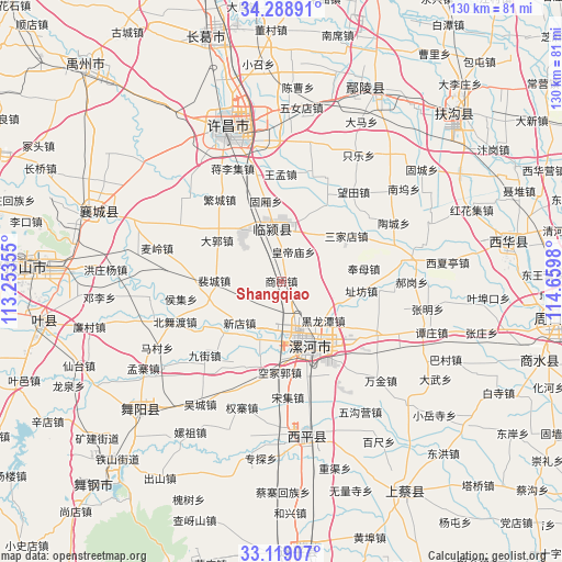
| Upper-left | 34.28891°, | 113.25355° |
| Center: | 33.70598°, | 113.95667° |
| Lower-right: | 33.11907°, | 114.6598° |
| Map W x H: | 130.1×130.1 km | = 80.8×80.8mi |
| max Lat: | 53.31946° ⇑31.2% North |
| Shangqiao: | 33.70598° |
| min Lat: | ⇓68.8% South 18.22056° |
| min Long | Shangqiao | max Long |
| 75.07348° | 113.95667° | 134.28917° |
| W 48.3%⇐ | ⇒51.7% E |
Elevation
Elevation of Shangqiao is 63 m = 207 ft, and this is 421.8 m = 1384 ft below average elevation for this country.
| Max E: |
5622 m = 18445 ft | 67.4% |
| Avg. | 484.8 m = 1591 ft | |
| Shangqiao | 63 m = 207 ft | |
Min E: |
-3 m = -10 ft | 32.6% |
See also: China elevation on elevation.city.
Geographical zone
Shangqiao is located in North temperate zone (between Tropic of Cancer and the Arctic Circle). Distance of this Northern Tropic circle is 1141.8 km =709.5 mi to South.| Distance of | km | miles | from Shangqiao |
|---|---|---|---|
| North Pole | 6259.3 | 3889.3 | to North |
| Arctic Circle | 3653.4 | 2270.1 | to North |
| Tropic Cancer | 1141.8 | 709.5 | to South |
| Equator | 3747.8 | 2328.8 | to South |


Nearby cities:
15 places around Shangqiao: (largest is in red/bold)
• Daguo
17.6 km =10.9 mi,  302°
302°
• Dizhuang
18.9 km =11.7 mi,  146°
146°
• Duqu
14.7 km =9.1 mi,  324°
324°
• Ganhechen
17.4 km =10.8 mi,  160°
160°
• Guxiang
18.9 km =11.7 mi,  349°
349°
• Huangdimiao
7.4 km =4.6 mi,  21°
21°
• Juling
17.4 km =10.8 mi,  1°
1°
• Lianhua
17.5 km =10.9 mi,  226°
226°
• Longcheng
11.6 km =7.2 mi,  199°
199°
• Luohe
17.7 km =11 mi, 153°
• Peicheng
15.5 km =9.6 mi,  270°
270°
• Taichen
7.7 km =4.8 mi,  335°
335°
• Taiwei
20.3 km =12.6 mi,  245°
245°
• Xindian
13.8 km =8.6 mi, 225°
• Yancheng Chengguanzhen
13.8 km =8.6 mi,  168°
168°
Sources, notices
• [Note1] Compared only with cities in China existing in our database
• [Src1] Map data: © OpenStreetMap contributors (CC-BY-SA)
• [Src2] Other city data from geonames.org with taken over terms of usage.
• [Src3] Geographical zone / Annual Mean Temperature by Robert A. Rohde @ Wikipedia
