Guxiang geodata
Guxiang (Henan) is a seat of a fourth-order administrative division; located in China in Asia/Shanghai (GMT+8) time zone. In our database, there are 1268 cities with bigger population. Compared to other cities in China, 69.5% of cities are located further ↓South; 51.9% of cities are located further →East and 66.8% of cities have higher elevation than Guxiang. Note1


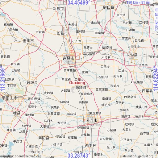
Guxiang GPS coordinates[2]
33° 52' 23.556" North, 113° 55' 11.316" East
| Map corner | latitude | longitude |
|---|---|---|
| Upper-left | 34.45499°, | 113.21669° |
| Center: | 33.87321°, | 113.91981° |
| Lower-right: | 33.28743°, | 114.62294° |
| Map W x H: | 129.8×129.8 km | = 80.7×80.7mi |
| max Lat: | 53.31946° ⇑30.5% North |
| Guxiang: | 33.87321° |
| min Lat: | ⇓69.5% South 18.22056° |
| min Long | Guxiang | max Long |
| 75.07348° | 113.91981° | 134.28917° |
| W 48.1%⇐ | ⇒51.9% E |
Elevation
Elevation of Guxiang is 65 m = 213 ft, and this is 419.8 m = 1377 ft below average elevation for this country.
| Max E: |
5622 m = 18445 ft | 66.8% |
| Avg. | 484.8 m = 1591 ft | |
| Guxiang | 65 m = 213 ft | |
Min E: |
-3 m = -10 ft | 33.2% |
See also: China elevation on elevation.city.
Geographical zone
Guxiang is located in North temperate zone (between Tropic of Cancer and the Arctic Circle). Distance of this Northern Tropic circle is 1160.4 km =721 mi to South.| Distance of | km | miles | from Guxiang |
|---|---|---|---|
| North Pole | 6240.7 | 3877.8 | to North |
| Arctic Circle | 3634.8 | 2258.6 | to North |
| Tropic Cancer | 1160.4 | 721 | to South |
| Equator | 3766.3 | 2340.3 | to South |


Nearby cities:
15 places around Guxiang: (largest is in red/bold)
• Daguo
14.7 km =9.1 mi,  231°
231°
• Duqu
8.5 km =5.3 mi,  217°
217°
• Fanhu
22.2 km =13.8 mi,  261°
261°
• Huangdimiao
13.2 km =8.2 mi,  152°
152°
• Jiangguanchi
14.9 km =9.3 mi,  341°
341°
• Jiangliji
10.8 km =6.7 mi,  313°
313°
• Juling
3.9 km =2.4 mi,  108°
108°
• Peicheng
22 km =13.7 mi,  213°
213°
• Shangqiao
18.9 km =11.7 mi,  169°
169°
• Shiqiao
6.1 km =3.8 mi, 340°
• Shuangmiao
26.6 km =16.5 mi,  278°
278°
• Taichen
11.6 km =7.2 mi,  179°
179°
• Wangmeng
7 km =4.3 mi,  27°
27°
• Xuchang
18.4 km =11.4 mi, 343°
• Zhangpan
14.8 km =9.2 mi, 26°
Sources, notices
• [Note1] Compared only with cities in China existing in our database
• [Src1] Map data: © OpenStreetMap contributors (CC-BY-SA)
• [Src2] Other city data from geonames.org with taken over terms of usage.
• [Src3] Geographical zone / Annual Mean Temperature by Robert A. Rohde @ Wikipedia
