Dikou geodata
Dikou (Fujian) is a seat of a fourth-order administrative division; located in China in Asia/Shanghai (GMT+8) time zone. In our database, there are 1268 cities with bigger population. Compared to other cities in China, 79.5% of cities are located further ↑North; 73% of cities are located further ←West and 59.5% of cities have lower elevation than Dikou. Note1


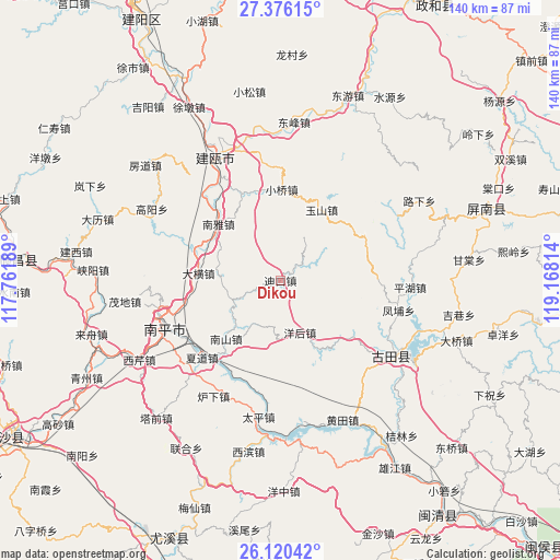
Dikou GPS coordinates[2]
26° 45' 0.072" North, 118° 27' 54.036" East
| Map corner | latitude | longitude |
|---|---|---|
| Upper-left | 27.37615°, | 117.76189° |
| Center: | 26.75002°, | 118.46501° |
| Lower-right: | 26.12042°, | 119.16814° |
| Map W x H: | 139.6×139.6 km | = 86.7×86.7mi |
| max Lat: | 53.31946° ⇑79.5% North |
| Dikou: | 26.75002° |
| min Lat: | ⇓20.5% South 18.22056° |
| min Long | Dikou | max Long |
| 75.07348° | 118.46501° | 134.28917° |
| W 73%⇐ | ⇒27% E |
Elevation
Elevation of Dikou is 254 m = 833 ft, and this is 230.8 m = 757 ft below average elevation for this country.
| Max E: |
5622 m = 18445 ft | 40.5% |
| Avg. | 484.8 m = 1591 ft | |
| Dikou | 254 m = 833 ft | |
Min E: |
-3 m = -10 ft | 59.5% |
See also: China elevation on elevation.city.
Geographical zone
Dikou is located in North temperate zone (between Tropic of Cancer and the Arctic Circle). Distance of this Northern Tropic circle is 368.4 km =228.9 mi to South.| Distance of | km | miles | from Dikou |
|---|---|---|---|
| North Pole | 7032.7 | 4369.9 | to North |
| Arctic Circle | 4426.9 | 2750.7 | to North |
| Tropic Cancer | 368.4 | 228.9 | to South |
| Equator | 2974.3 | 1848.1 | to South |


Nearby cities:
15 places around Dikou: (largest is in red/bold)
• Chengdong
33.2 km =20.6 mi,  125°
125°
• Chimen
22.8 km =14.2 mi,  184°
184°
• Daheng
20.7 km =12.9 mi,  275°
275°
• Fengpu
30.2 km =18.8 mi,  104°
104°
• Luxia
33.4 km =20.8 mi,  210°
210°
• Mangdang
31.4 km =19.5 mi,  257°
257°
• Nanping
31.2 km =19.4 mi,  248°
248°
• Nanshan
20.1 km =12.5 mi,  223°
223°
• Nanya
21 km =13 mi,  311°
311°
• Pinghu
32.5 km =20.2 mi,  92°
92°
• Shuangzhu
22.3 km =13.9 mi, 126°
• Xiadao
27.5 km =17.1 mi, 224°
• Xiaoqiao
22.7 km =14.1 mi,  0°
0°
• Yanghou
12.9 km =8 mi,  160°
160°
• Yushan
20.3 km =12.6 mi,  29°
29°
Sources, notices
• [Note1] Compared only with cities in China existing in our database
• [Src1] Map data: © OpenStreetMap contributors (CC-BY-SA)
• [Src2] Other city data from geonames.org with taken over terms of usage.
• [Src3] Geographical zone / Annual Mean Temperature by Robert A. Rohde @ Wikipedia
