Yanghou geodata
Yanghou (Fujian) is a populated place; located in China in Asia/Shanghai (GMT+8) time zone. With population of 2,530 people, there are 982 cities with bigger population in this country. Compared to other cities in China, 79.9% of cities are located further ↑North; 73.3% of cities are located further ←West and 64.5% of cities have lower elevation than Yanghou. Note1


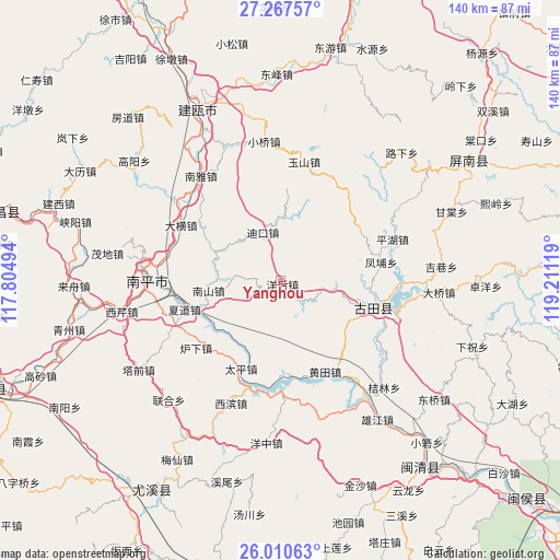
Yanghou GPS coordinates[2]
26° 38' 26.988" North, 118° 30' 29.016" East
| Map corner | latitude | longitude |
|---|---|---|
| Upper-left | 27.26757°, | 117.80494° |
| Center: | 26.64083°, | 118.50806° |
| Lower-right: | 26.01063°, | 119.21119° |
| Map W x H: | 139.8×139.8 km | = 86.9×86.9mi |
| max Lat: | 53.31946° ⇑79.9% North |
| Yanghou: | 26.64083° |
| min Lat: | ⇓20.1% South 18.22056° |
| min Long | Yanghou | max Long |
| 75.07348° | 118.50806° | 134.28917° |
| W 73.3%⇐ | ⇒26.7% E |
Elevation
Elevation of Yanghou is 318 m = 1043 ft, and this is 166.8 m = 547 ft below average elevation for this country.
| Max E: |
5622 m = 18445 ft | 35.5% |
| Avg. | 484.8 m = 1591 ft | |
| Yanghou | 318 m = 1043 ft | |
Min E: |
-3 m = -10 ft | 64.5% |
See also: China elevation on elevation.city.
Geographical zone
Yanghou is located in North temperate zone (between Tropic of Cancer and the Arctic Circle). Distance of this Northern Tropic circle is 356.3 km =221.4 mi to South.| Distance of | km | miles | from Yanghou |
|---|---|---|---|
| North Pole | 7044.9 | 4377.5 | to North |
| Arctic Circle | 4439 | 2758.3 | to North |
| Tropic Cancer | 356.3 | 221.4 | to South |
| Equator | 2962.2 | 1840.6 | to South |


Nearby cities:
15 places around Yanghou: (largest is in red/bold)
• Chengdong
23.9 km =14.9 mi,  106°
106°
• Chimen
12.2 km =7.6 mi,  209°
209°
• Daheng
28.5 km =17.7 mi,  299°
299°
• Dikou
12.9 km =8 mi,  340°
340°
• Fengpu
25.5 km =15.8 mi,  79°
79°
• Huangtian
25.3 km =15.7 mi,  152°
152°
• Luxia
26.9 km =16.7 mi,  231°
231°
• Nanshan
18.4 km =11.4 mi,  262°
262°
• Pinghu
30.2 km =18.8 mi,  69°
69°
• Shuangzhu
13.7 km =8.5 mi,  94°
94°
• Songji
24.2 km =15 mi, 107°
• Taiping
23.5 km =14.6 mi,  202°
202°
• Xiadao
24.8 km =15.4 mi,  252°
252°
• Youxikou
27.7 km =17.2 mi,  193°
193°
• Zhanghuban
28.4 km =17.6 mi,  184°
184°
Sources, notices
• [Note1] Compared only with cities in China existing in our database
• [Src1] Map data: © OpenStreetMap contributors (CC-BY-SA)
• [Src2] Other city data from geonames.org with taken over terms of usage.
• [Src3] Geographical zone / Annual Mean Temperature by Robert A. Rohde @ Wikipedia
