Shatou geodata
Shatou (Jiangsu) is a seat of a fourth-order administrative division; located in China in Asia/Shanghai (GMT+8) time zone. In our database, there are 1268 cities with bigger population. Compared to other cities in China, 63% of cities are located further ↓South; 78.9% of cities are located further ←West and 97.2% of cities have higher elevation than Shatou. Note1


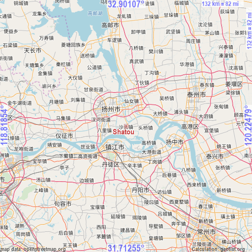
Shatou GPS coordinates[2]
32° 18' 31.536" North, 119° 31' 17.976" East
| Map corner | latitude | longitude |
|---|---|---|
| Upper-left | 32.90107°, | 118.81854° |
| Center: | 32.30876°, | 119.52166° |
| Lower-right: | 31.71255°, | 120.22479° |
| Map W x H: | 132.2×132.2 km | = 82.1×82.1mi |
| max Lat: | 53.31946° ⇑37% North |
| Shatou: | 32.30876° |
| min Lat: | ⇓63% South 18.22056° |
| min Long | Shatou | max Long |
| 75.07348° | 119.52166° | 134.28917° |
| W 78.9%⇐ | ⇒21.1% E |
Elevation
Elevation of Shatou is 5 m = 16 ft, and this is 479.8 m = 1574 ft below average elevation for this country.
| Max E: |
5622 m = 18445 ft | 97.2% |
| Avg. | 484.8 m = 1591 ft | |
| Shatou | 5 m = 16 ft | |
Min E: |
-3 m = -10 ft | 2.8% |
See also: China elevation on elevation.city.
Geographical zone
Shatou is located in North temperate zone (between Tropic of Cancer and the Arctic Circle). Distance of this Northern Tropic circle is 986.5 km =613 mi to South.| Distance of | km | miles | from Shatou |
|---|---|---|---|
| North Pole | 6414.7 | 3985.9 | to North |
| Arctic Circle | 3808.8 | 2366.7 | to North |
| Tropic Cancer | 986.5 | 613 | to South |
| Equator | 3592.4 | 2232.2 | to South |


Nearby cities:
15 places around Shatou: (largest is in red/bold)
• Bali
11.7 km =7.3 mi,  260°
260°
• Chahe
13.6 km =8.5 mi,  284°
284°
• Hangji
6.7 km =4.2 mi,  9°
9°
• Hanshang
14.3 km =8.9 mi,  302°
302°
• Lidian
5.3 km =3.3 mi,  74°
74°
• Shiqiao
6.2 km =3.9 mi,  273°
273°
• Tangwang
9 km =5.6 mi,  319°
319°
• Wantou
13.3 km =8.3 mi,  346°
346°
• Wenhe
13.1 km =8.1 mi, 317°
• Xiangshan
12.7 km =7.9 mi,  177°
177°
• Xiannü
13.8 km =8.6 mi,  15°
15°
• Xinba
8.7 km =5.4 mi,  112°
112°
• Yangzhou
12.7 km =7.9 mi, 320°
• Zhengdonglu
13.8 km =8.6 mi,  200°
200°
• Zhenjiang
12.6 km =7.8 mi,  209°
209°
Sources, notices
• [Note1] Compared only with cities in China existing in our database
• [Src1] Map data: © OpenStreetMap contributors (CC-BY-SA)
• [Src2] Other city data from geonames.org with taken over terms of usage.
• [Src3] Geographical zone / Annual Mean Temperature by Robert A. Rohde @ Wikipedia
