Xiangshui geodata
Xiangshui (Hainan) is a seat of a fourth-order administrative division; located in China in Asia/Shanghai (GMT+8) time zone. In our database, there are 1268 cities with bigger population. Compared to other cities in China, 99.8% of cities are located further ↑North; 73.3% of cities are located further →East and 60.8% of cities have higher elevation than Xiangshui. Note1


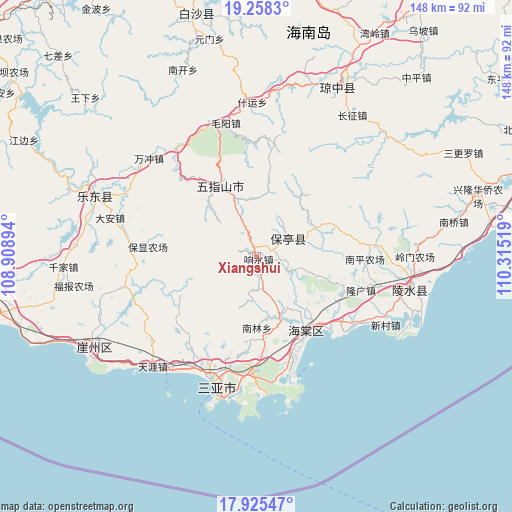
Xiangshui GPS coordinates[2]
18° 35' 35.484" North, 109° 36' 43.416" East
| Map corner | latitude | longitude |
|---|---|---|
| Upper-left | 19.2583°, | 108.90894° |
| Center: | 18.59319°, | 109.61206° |
| Lower-right: | 17.92547°, | 110.31519° |
| Map W x H: | 148.2×148.2 km | = 92.1×92.1mi |
| max Lat: | 53.31946° ⇑99.8% North |
| Xiangshui: | 18.59319° |
| min Lat: | ⇓0.2% South 18.22056° |
| min Long | Xiangshui | max Long |
| 75.07348° | 109.61206° | 134.28917° |
| W 26.7%⇐ | ⇒73.3% E |
Elevation
Elevation of Xiangshui is 94 m = 308 ft, and this is 390.8 m = 1282 ft below average elevation for this country.
| Max E: |
5622 m = 18445 ft | 60.8% |
| Avg. | 484.8 m = 1591 ft | |
| Xiangshui | 94 m = 308 ft | |
Min E: |
-3 m = -10 ft | 39.2% |
See also: China elevation on elevation.city.
Geographical zone
Xiangshui is located in North Torrid zone (between Equator and Tropic of Cancer). Distance of this Northern Tropic circle is 538.6 km =334.7 mi to North.| Distance of | km | miles | from Xiangshui |
|---|---|---|---|
| North Pole | 7939.7 | 4933.5 | to North |
| Arctic Circle | 5333.8 | 3314.3 | to North |
| Tropic Cancer | 538.6 | 334.7 | to North |
| Equator | 2067.4 | 1284.6 | to South |


Nearby cities:
15 places around Xiangshui: (largest is in red/bold)
• Baocheng
10.6 km =6.6 mi,  60°
60°
• Benhao
33.7 km =20.9 mi,  85°
85°
• Changhao
21.4 km =13.3 mi,  318°
318°
• Chongshan
24 km =14.9 mi,  330°
330°
• Haitangwan
25.6 km =15.9 mi,  145°
145°
• Jiamao
9.9 km =6.2 mi,  114°
114°
• Liugong
18.5 km =11.5 mi, 108°
• Longguang
31.8 km =19.8 mi, 107°
• Nanlin
20 km =12.4 mi,  180°
180°
• Nansheng
15 km =9.3 mi,  353°
353°
• Qunying
23.6 km =14.7 mi, 88°
• Sandao
15.1 km =9.4 mi,  158°
158°
• Shiling
19.3 km =12 mi,  65°
65°
• Xinzheng
5.7 km =3.5 mi,  167°
167°
• Yingzhou
31.5 km =19.6 mi,  127°
127°
Sources, notices
• [Note1] Compared only with cities in China existing in our database
• [Src1] Map data: © OpenStreetMap contributors (CC-BY-SA)
• [Src2] Other city data from geonames.org with taken over terms of usage.
• [Src3] Geographical zone / Annual Mean Temperature by Robert A. Rohde @ Wikipedia
