Sandao geodata
Sandao (Hainan) is a seat of a fourth-order administrative division; located in China in Asia/Shanghai (GMT+8) time zone. In our database, there are 1268 cities with bigger population. Compared to other cities in China, 99.9% of cities are located further ↑North; 73% of cities are located further →East and 64.5% of cities have higher elevation than Sandao. Note1


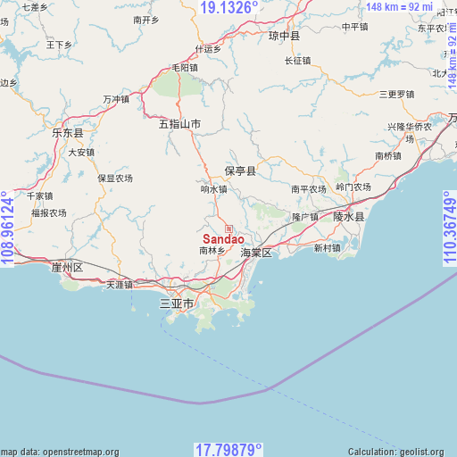
Sandao GPS coordinates[2]
18° 28' 1.164" North, 109° 39' 51.696" East
| Map corner | latitude | longitude |
|---|---|---|
| Upper-left | 19.1326°, | 108.96124° |
| Center: | 18.46699°, | 109.66436° |
| Lower-right: | 17.79879°, | 110.36749° |
| Map W x H: | 148.3×148.3 km | = 92.1×92.1mi |
| max Lat: | 53.31946° ⇑99.9% North |
| Sandao: | 18.46699° |
| min Lat: | ⇓0.1% South 18.22056° |
| min Long | Sandao | max Long |
| 75.07348° | 109.66436° | 134.28917° |
| W 27%⇐ | ⇒73% E |
Elevation
Elevation of Sandao is 75 m = 246 ft, and this is 409.8 m = 1344 ft below average elevation for this country.
| Max E: |
5622 m = 18445 ft | 64.5% |
| Avg. | 484.8 m = 1591 ft | |
| Sandao | 75 m = 246 ft | |
Min E: |
-3 m = -10 ft | 35.5% |
See also: China elevation on elevation.city.
Geographical zone
Sandao is located in North Torrid zone (between Equator and Tropic of Cancer). Distance of this Northern Tropic circle is 552.6 km =343.4 mi to North.| Distance of | km | miles | from Sandao |
|---|---|---|---|
| North Pole | 7953.7 | 4942.2 | to North |
| Arctic Circle | 5347.8 | 3323 | to North |
| Tropic Cancer | 552.6 | 343.4 | to North |
| Equator | 2053.3 | 1275.9 | to South |


Nearby cities:
15 places around Sandao: (largest is in red/bold)
• Baocheng
19.6 km =12.2 mi,  10°
10°
• Fenghuang
29.4 km =18.3 mi,  231°
231°
• Haitangwan
11.5 km =7.1 mi,  128°
128°
• Jiamao
10.5 km =6.5 mi,  19°
19°
• Liugong
14.5 km =9 mi,  55°
55°
• Longguang
25.1 km =15.6 mi,  80°
80°
• Nanlin
8.4 km =5.2 mi,  224°
224°
• Nansheng
29.9 km =18.6 mi,  346°
346°
• Qunying
23.4 km =14.5 mi,  50°
50°
• Sanya
30 km =18.6 mi,  214°
214°
• Shiling
25 km =15.5 mi,  28°
28°
• Tiandu
22.1 km =13.7 mi,  203°
203°
• Xiangshui
15.1 km =9.4 mi,  338°
338°
• Xinzheng
9.5 km =5.9 mi,  333°
333°
• Yingzhou
20.2 km =12.6 mi,  104°
104°
Sources, notices
• [Note1] Compared only with cities in China existing in our database
• [Src1] Map data: © OpenStreetMap contributors (CC-BY-SA)
• [Src2] Other city data from geonames.org with taken over terms of usage.
• [Src3] Geographical zone / Annual Mean Temperature by Robert A. Rohde @ Wikipedia
