Xiabao geodata
Xiabao (Zhejiang) is a seat of a fourth-order administrative division; located in China in Asia/Shanghai (GMT+8) time zone. In our database, there are 1268 cities with bigger population. Compared to other cities in China, 57.6% of cities are located further ↑North; 78.7% of cities are located further ←West and 61.7% of cities have higher elevation than Xiabao. Note1


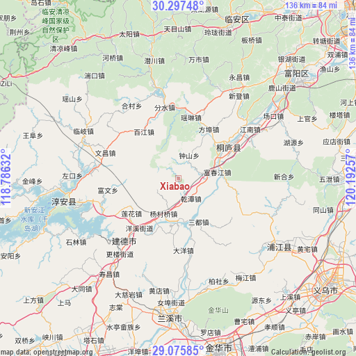
Xiabao GPS coordinates[2]
29° 41' 18.672" North, 119° 29' 21.984" East
| Map corner | latitude | longitude |
|---|---|---|
| Upper-left | 30.29748°, | 118.78632° |
| Center: | 29.68852°, | 119.48944° |
| Lower-right: | 29.07585°, | 120.19257° |
| Map W x H: | 135.8×135.8 km | = 84.4×84.4mi |
| max Lat: | 53.31946° ⇑57.6% North |
| Xiabao: | 29.68852° |
| min Lat: | ⇓42.4% South 18.22056° |
| min Long | Xiabao | max Long |
| 75.07348° | 119.48944° | 134.28917° |
| W 78.7%⇐ | ⇒21.3% E |
Elevation
Elevation of Xiabao is 89 m = 292 ft, and this is 395.8 m = 1299 ft below average elevation for this country.
| Max E: |
5622 m = 18445 ft | 61.7% |
| Avg. | 484.8 m = 1591 ft | |
| Xiabao | 89 m = 292 ft | |
Min E: |
-3 m = -10 ft | 38.3% |
See also: China elevation on elevation.city.
Geographical zone
Xiabao is located in North temperate zone (between Tropic of Cancer and the Arctic Circle). Distance of this Northern Tropic circle is 695.1 km =431.9 mi to South.| Distance of | km | miles | from Xiabao |
|---|---|---|---|
| North Pole | 6706 | 4166.9 | to North |
| Arctic Circle | 4100.1 | 2547.7 | to North |
| Tropic Cancer | 695.1 | 431.9 | to South |
| Equator | 3301.1 | 2051.2 | to South |


Nearby cities:
15 places around Xiabao: (largest is in red/bold)
• Baijiang
22.2 km =13.8 mi,  324°
324°
• Bipu
26.2 km =16.3 mi,  7°
7°
• Dayang
27.4 km =17 mi,  176°
176°
• Donghui
27.1 km =16.8 mi,  311°
311°
• Eshan
14.8 km =9.2 mi,  32°
32°
• Fangbu
22.1 km =13.7 mi, 31°
• Fenshui
27.5 km =17.1 mi,  348°
348°
• Fuchunjiang
15.3 km =9.5 mi,  79°
79°
• Gaoxiang
28.4 km =17.6 mi,  20°
20°
• Jiuxian
18.1 km =11.2 mi,  45°
45°
• Meicheng
16.2 km =10.1 mi, 176°
• Qiantan
9 km =5.6 mi,  147°
147°
• Qintang
7.8 km =4.8 mi,  67°
67°
• Sandu
18.7 km =11.6 mi,  155°
155°
• Yaolin
23.9 km =14.9 mi, 11°
Sources, notices
• [Note1] Compared only with cities in China existing in our database
• [Src1] Map data: © OpenStreetMap contributors (CC-BY-SA)
• [Src2] Other city data from geonames.org with taken over terms of usage.
• [Src3] Geographical zone / Annual Mean Temperature by Robert A. Rohde @ Wikipedia
