Wuhu geodata
Wuhu (Anhui) is a seat of a second-order administrative division; located in China in Asia/Shanghai (GMT+8) time zone. With population of 507,524 people, there are 127 cities with bigger population in this country. Compared to other cities in China, 57.4% of cities are located further ↓South; 72.4% of cities are located further ←West and 83.4% of cities have higher elevation than Wuhu. Note1


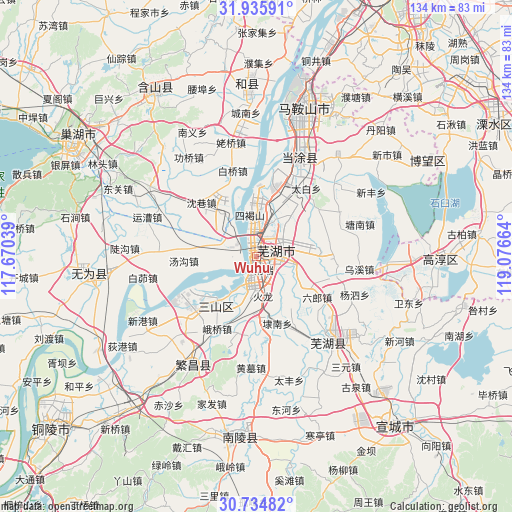
Wuhu GPS coordinates[2]
31° 20' 14.208" North, 118° 22' 24.636" East
| Map corner | latitude | longitude |
|---|---|---|
| Upper-left | 31.93591°, | 117.67039° |
| Center: | 31.33728°, | 118.37351° |
| Lower-right: | 30.73482°, | 119.07664° |
| Map W x H: | 133.5×133.5 km | = 83×83mi |
| max Lat: | 53.31946° ⇑42.6% North |
| Wuhu: | 31.33728° |
| min Lat: | ⇓57.4% South 18.22056° |
| min Long | Wuhu | max Long |
| 75.07348° | 118.37351° | 134.28917° |
| W 72.4%⇐ | ⇒27.6% E |
Elevation
Elevation of Wuhu is 19 m = 62 ft, and this is 465.8 m = 1528 ft below average elevation for this country.
| Max E: |
5622 m = 18445 ft | 83.4% |
| Avg. | 484.8 m = 1591 ft | |
| Wuhu | 19 m = 62 ft | |
Min E: |
-3 m = -10 ft | 16.6% |
See also: Wuhu elevation on elevation.city.
Geographical zone
Wuhu is located in North temperate zone (between Tropic of Cancer and the Arctic Circle). Distance of this Northern Tropic circle is 878.5 km =545.9 mi to South.| Distance of | km | miles | from Wuhu |
|---|---|---|---|
| North Pole | 6522.7 | 4053 | to North |
| Arctic Circle | 3916.8 | 2433.8 | to North |
| Tropic Cancer | 878.5 | 545.9 | to South |
| Equator | 3484.4 | 2165.1 | to South |


Nearby cities:
15 places around Wuhu: (largest is in red/bold)
• Beijinglu
2 km =1.2 mi,  145°
145°
• Erba
4.1 km =2.5 mi,  281°
281°
• Guandou
5.1 km =3.2 mi,  26°
26°
• Huolonggang
10 km =6.2 mi,  168°
168°
• Jinghu
1.2 km =0.7 mi,  336°
336°
• Jingshan
7.7 km =4.8 mi,  110°
110°
• Lugang
8 km =5 mi,  206°
206°
• Matang
3.4 km =2.1 mi,  137°
137°
• Qingshui
10.1 km =6.3 mi,  102°
102°
• Sanjiang
1.7 km =1.1 mi,  316°
316°
• Wanli
6.8 km =4.2 mi,  12°
12°
• Xiheshan
12 km =7.5 mi,  348°
348°
• Yijiang
2.7 km =1.7 mi, 206°
• Yitai
12.7 km =7.9 mi,  122°
122°
• Yuxikou
12.3 km =7.6 mi,  328°
328°
Sources, notices
• [Note1] Compared only with cities in China existing in our database
• [Src1] Map data: © OpenStreetMap contributors (CC-BY-SA)
• [Src2] Other city data from geonames.org with taken over terms of usage.
• [Src3] Geographical zone / Annual Mean Temperature by Robert A. Rohde @ Wikipedia
