Beijinglu geodata
Beijinglu (Anhui) is a seat of a third-order administrative division; located in China in Asia/Shanghai (GMT+8) time zone. In our database, there are 1268 cities with bigger population. Compared to other cities in China, 57.3% of cities are located further ↓South; 72.5% of cities are located further ←West and 87.7% of cities have higher elevation than Beijinglu. Note1


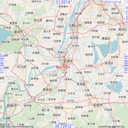
Beijinglu GPS coordinates[2]
31° 19' 21.648" North, 118° 23' 6.18" East
| Map corner | latitude | longitude |
|---|---|---|
| Upper-left | 31.9214°, | 117.68193° |
| Center: | 31.32268°, | 118.38505° |
| Lower-right: | 30.72012°, | 119.08818° |
| Map W x H: | 133.6×133.6 km | = 83×83mi |
| max Lat: | 53.31946° ⇑42.7% North |
| Beijinglu: | 31.32268° |
| min Lat: | ⇓57.3% South 18.22056° |
| min Long | Beijinglu | max Long |
| 75.07348° | 118.38505° | 134.28917° |
| W 72.5%⇐ | ⇒27.5% E |
Elevation
Elevation of Beijinglu is 12 m = 39 ft, and this is 472.8 m = 1551 ft below average elevation for this country.
| Max E: |
5622 m = 18445 ft | 87.7% |
| Avg. | 484.8 m = 1591 ft | |
| Beijinglu | 12 m = 39 ft | |
Min E: |
-3 m = -10 ft | 12.3% |
See also: China elevation on elevation.city.
Geographical zone
Beijinglu is located in North temperate zone (between Tropic of Cancer and the Arctic Circle). Distance of this Northern Tropic circle is 876.8 km =544.8 mi to South.| Distance of | km | miles | from Beijinglu |
|---|---|---|---|
| North Pole | 6524.3 | 4054 | to North |
| Arctic Circle | 3918.4 | 2434.8 | to North |
| Tropic Cancer | 876.8 | 544.8 | to South |
| Equator | 3482.8 | 2164.1 | to South |


Nearby cities:
15 places around Beijinglu: (largest is in red/bold)
• Dazha
13.9 km =8.6 mi,  63°
63°
• Erba
5.7 km =3.5 mi,  295°
295°
• Guandou
6.3 km =3.9 mi,  10°
10°
• Huolonggang
8.2 km =5.1 mi,  173°
173°
• Jinghu
3.2 km =2 mi,  330°
330°
• Jingshan
6.2 km =3.9 mi,  99°
99°
• Lugang
7.3 km =4.5 mi,  220°
220°
• Matang
1.5 km =0.9 mi,  125°
125°
• Qingshui
8.8 km =5.5 mi,  93°
93°
• Sanjiang
3.6 km =2.2 mi,  321°
321°
• Wanli
8.3 km =5.2 mi,  2°
2°
• Wuhu
2 km =1.2 mi, 325°
• Xiheshan
13.8 km =8.6 mi,  345°
345°
• Yijiang
2.5 km =1.6 mi,  250°
250°
• Yitai
10.9 km =6.8 mi,  118°
118°
Sources, notices
• [Note1] Compared only with cities in China existing in our database
• [Src1] Map data: © OpenStreetMap contributors (CC-BY-SA)
• [Src2] Other city data from geonames.org with taken over terms of usage.
• [Src3] Geographical zone / Annual Mean Temperature by Robert A. Rohde @ Wikipedia
