Xiheshan geodata
Xiheshan (Anhui) is a seat of a fourth-order administrative division; located in China in Asia/Shanghai (GMT+8) time zone. In our database, there are 1268 cities with bigger population. Compared to other cities in China, 58% of cities are located further ↓South; 72.3% of cities are located further ←West and 84.3% of cities have higher elevation than Xiheshan. Note1


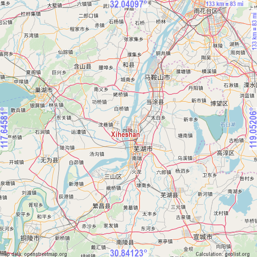
Xiheshan GPS coordinates[2]
31° 26' 34.872" North, 118° 20' 56.148" East
| Map corner | latitude | longitude |
|---|---|---|
| Upper-left | 32.04097°, | 117.64581° |
| Center: | 31.44302°, | 118.34893° |
| Lower-right: | 30.84123°, | 119.05206° |
| Map W x H: | 133.4×133.4 km | = 82.9×82.9mi |
| max Lat: | 53.31946° ⇑42% North |
| Xiheshan: | 31.44302° |
| min Lat: | ⇓58% South 18.22056° |
| min Long | Xiheshan | max Long |
| 75.07348° | 118.34893° | 134.28917° |
| W 72.3%⇐ | ⇒27.7% E |
Elevation
Elevation of Xiheshan is 17 m = 56 ft, and this is 467.8 m = 1535 ft below average elevation for this country.
| Max E: |
5622 m = 18445 ft | 84.3% |
| Avg. | 484.8 m = 1591 ft | |
| Xiheshan | 17 m = 56 ft | |
Min E: |
-3 m = -10 ft | 15.7% |
See also: China elevation on elevation.city.
Geographical zone
Xiheshan is located in North temperate zone (between Tropic of Cancer and the Arctic Circle). Distance of this Northern Tropic circle is 890.2 km =553.1 mi to South.| Distance of | km | miles | from Xiheshan |
|---|---|---|---|
| North Pole | 6510.9 | 4045.7 | to North |
| Arctic Circle | 3905 | 2426.5 | to North |
| Tropic Cancer | 890.2 | 553.1 | to South |
| Equator | 3496.1 | 2172.4 | to South |


Nearby cities:
15 places around Xiheshan: (largest is in red/bold)
• Baiqiao
11.2 km =7 mi,  339°
339°
• Beijinglu
13.8 km =8.6 mi,  165°
165°
• Daqiao
6.2 km =3.9 mi,  66°
66°
• Erba
11.1 km =6.9 mi,  188°
188°
• Guandou
8.6 km =5.3 mi,  147°
147°
• Jinghu
10.8 km =6.7 mi, 170°
• Longshanqiao
13.9 km =8.6 mi,  64°
64°
• Matang
15 km =9.3 mi,  161°
161°
• Niandou
10.5 km =6.5 mi,  95°
95°
• Sanjiang
10.6 km =6.6 mi, 173°
• Wanli
6.4 km =4 mi,  143°
143°
• Wuhu
12 km =7.5 mi, 168°
• Xinqiao
12.4 km =7.7 mi,  51°
51°
• Yijiang
14.2 km =8.8 mi,  175°
175°
• Yuxikou
4.3 km =2.7 mi,  252°
252°
Sources, notices
• [Note1] Compared only with cities in China existing in our database
• [Src1] Map data: © OpenStreetMap contributors (CC-BY-SA)
• [Src2] Other city data from geonames.org with taken over terms of usage.
• [Src3] Geographical zone / Annual Mean Temperature by Robert A. Rohde @ Wikipedia
