Wanli geodata
Wanli (Anhui) is a seat of a fourth-order administrative division; located in China in Asia/Shanghai (GMT+8) time zone. In our database, there are 1268 cities with bigger population. Compared to other cities in China, 57.7% of cities are located further ↓South; 72.5% of cities are located further ←West and 86.9% of cities have higher elevation than Wanli. Note1


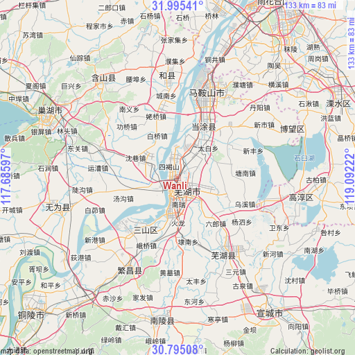
Wanli GPS coordinates[2]
31° 23' 49.776" North, 118° 23' 20.724" East
| Map corner | latitude | longitude |
|---|---|---|
| Upper-left | 31.99541°, | 117.68597° |
| Center: | 31.39716°, | 118.38909° |
| Lower-right: | 30.79508°, | 119.09222° |
| Map W x H: | 133.5×133.5 km | = 83×83mi |
| max Lat: | 53.31946° ⇑42.3% North |
| Wanli: | 31.39716° |
| min Lat: | ⇓57.7% South 18.22056° |
| min Long | Wanli | max Long |
| 75.07348° | 118.38909° | 134.28917° |
| W 72.5%⇐ | ⇒27.5% E |
Elevation
Elevation of Wanli is 13 m = 43 ft, and this is 471.8 m = 1548 ft below average elevation for this country.
| Max E: |
5622 m = 18445 ft | 86.9% |
| Avg. | 484.8 m = 1591 ft | |
| Wanli | 13 m = 43 ft | |
Min E: |
-3 m = -10 ft | 13.1% |
See also: China elevation on elevation.city.
Geographical zone
Wanli is located in North temperate zone (between Tropic of Cancer and the Arctic Circle). Distance of this Northern Tropic circle is 885.1 km =550 mi to South.| Distance of | km | miles | from Wanli |
|---|---|---|---|
| North Pole | 6516 | 4048.9 | to North |
| Arctic Circle | 3910.1 | 2429.6 | to North |
| Tropic Cancer | 885.1 | 550 | to South |
| Equator | 3491 | 2169.2 | to South |


Nearby cities:
15 places around Wanli: (largest is in red/bold)
• Beijinglu
8.3 km =5.2 mi,  182°
182°
• Daqiao
7.8 km =4.8 mi,  13°
13°
• Dazha
12.2 km =7.6 mi,  99°
99°
• Erba
8.1 km =5 mi,  223°
223°
• Guandou
2.2 km =1.4 mi,  158°
158°
• Jinghu
5.9 km =3.7 mi,  199°
199°
• Jingshan
10.9 km =6.8 mi,  148°
148°
• Matang
9.2 km =5.7 mi,  174°
174°
• Niandou
7.8 km =4.8 mi,  58°
58°
• Qingshui
12.2 km =7.6 mi,  136°
136°
• Sanjiang
6.1 km =3.8 mi,  205°
205°
• Wuhu
6.8 km =4.2 mi,  192°
192°
• Xiheshan
6.4 km =4 mi,  323°
323°
• Yijiang
9.5 km =5.9 mi, 196°
• Yuxikou
8.8 km =5.5 mi,  295°
295°
Sources, notices
• [Note1] Compared only with cities in China existing in our database
• [Src1] Map data: © OpenStreetMap contributors (CC-BY-SA)
• [Src2] Other city data from geonames.org with taken over terms of usage.
• [Src3] Geographical zone / Annual Mean Temperature by Robert A. Rohde @ Wikipedia
