Weidi geodata
Weidi (Guangdong) is a seat of a fourth-order administrative division; located in China in Asia/Shanghai (GMT+8) time zone. In our database, there are 1268 cities with bigger population. Compared to other cities in China, 95.6% of cities are located further ↑North; 64.2% of cities are located further →East and 70.3% of cities have higher elevation than Weidi. Note1


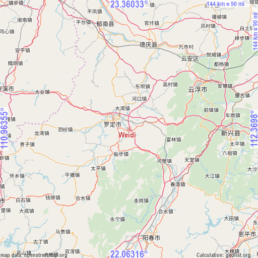
Weidi GPS coordinates[2]
22° 42' 47.808" North, 111° 40' 0.012" East
| Map corner | latitude | longitude |
|---|---|---|
| Upper-left | 23.36033°, | 110.96355° |
| Center: | 22.71328°, | 111.66667° |
| Lower-right: | 22.06316°, | 112.3698° |
| Map W x H: | 144.2×144.2 km | = 89.6×89.6mi |
| max Lat: | 53.31946° ⇑95.6% North |
| Weidi: | 22.71328° |
| min Lat: | ⇓4.4% South 18.22056° |
| min Long | Weidi | max Long |
| 75.07348° | 111.66667° | 134.28917° |
| W 35.8%⇐ | ⇒64.2% E |
Elevation
Elevation of Weidi is 51 m = 167 ft, and this is 433.8 m = 1423 ft below average elevation for this country.
| Max E: |
5622 m = 18445 ft | 70.3% |
| Avg. | 484.8 m = 1591 ft | |
| Weidi | 51 m = 167 ft | |
Min E: |
-3 m = -10 ft | 29.7% |
See also: China elevation on elevation.city.
Geographical zone
Weidi is located in North Torrid zone (between Equator and Tropic of Cancer). Distance of this Northern Tropic circle is 80.4 km =50 mi to North.| Distance of | km | miles | from Weidi |
|---|---|---|---|
| North Pole | 7481.6 | 4648.8 | to North |
| Arctic Circle | 4875.7 | 3029.6 | to North |
| Tropic Cancer | 80.4 | 50 | to North |
| Equator | 2525.5 | 1569.3 | to South |


Nearby cities:
15 places around Weidi: (largest is in red/bold)
• Baishi
17.8 km =11.1 mi,  47°
47°
• Bingtang
10.8 km =6.7 mi,  158°
158°
• Chengdong
8.2 km =5.1 mi,  306°
306°
• Chengxi
15 km =9.3 mi,  286°
286°
• Chuanbu
14.3 km =8.9 mi,  198°
198°
• Dawan
12.6 km =7.8 mi,  342°
342°
• Fucheng
12.5 km =7.8 mi, 307°
• Huashi
6.2 km =3.9 mi,  18°
18°
• Jinji
15.9 km =9.9 mi,  89°
89°
• Luocheng
11.8 km =7.3 mi,  301°
301°
• Luoping
14.2 km =8.8 mi,  226°
226°
• Pingtang
10.2 km =6.3 mi,  61°
61°
• Shengjiang
16.1 km =10 mi,  267°
267°
• Shuangdong
11.5 km =7.1 mi,  320°
320°
• Sulong
5.9 km =3.7 mi, 274°
Sources, notices
• [Note1] Compared only with cities in China existing in our database
• [Src1] Map data: © OpenStreetMap contributors (CC-BY-SA)
• [Src2] Other city data from geonames.org with taken over terms of usage.
• [Src3] Geographical zone / Annual Mean Temperature by Robert A. Rohde @ Wikipedia
