Pingtang geodata
Pingtang (Guangdong) is a seat of a fourth-order administrative division; located in China in Asia/Shanghai (GMT+8) time zone. In our database, there are 1268 cities with bigger population. Compared to other cities in China, 95.5% of cities are located further ↑North; 63.7% of cities are located further →East and 58.2% of cities have higher elevation than Pingtang. Note1


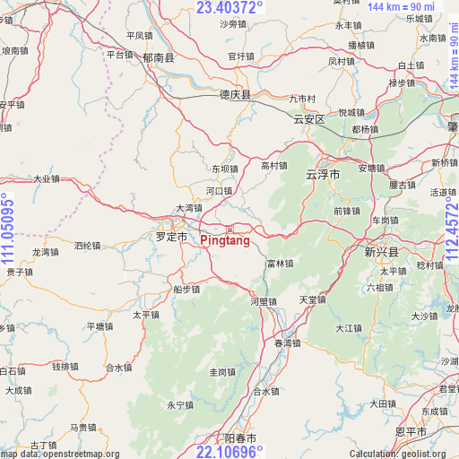
Pingtang GPS coordinates[2]
22° 45' 24.768" North, 111° 45' 14.652" East
| Map corner | latitude | longitude |
|---|---|---|
| Upper-left | 23.40372°, | 111.05095° |
| Center: | 22.75688°, | 111.75407° |
| Lower-right: | 22.10696°, | 112.4572° |
| Map W x H: | 144.2×144.2 km | = 89.6×89.6mi |
| max Lat: | 53.31946° ⇑95.5% North |
| Pingtang: | 22.75688° |
| min Lat: | ⇓4.5% South 18.22056° |
| min Long | Pingtang | max Long |
| 75.07348° | 111.75407° | 134.28917° |
| W 36.3%⇐ | ⇒63.7% E |
Elevation
Elevation of Pingtang is 110 m = 361 ft, and this is 374.8 m = 1230 ft below average elevation for this country.
| Max E: |
5622 m = 18445 ft | 58.2% |
| Avg. | 484.8 m = 1591 ft | |
| Pingtang | 110 m = 361 ft | |
Min E: |
-3 m = -10 ft | 41.8% |
See also: China elevation on elevation.city.
Geographical zone
Pingtang is located in North Torrid zone (between Equator and Tropic of Cancer). Distance of this Northern Tropic circle is 75.6 km =47 mi to North.| Distance of | km | miles | from Pingtang |
|---|---|---|---|
| North Pole | 7476.7 | 4645.8 | to North |
| Arctic Circle | 4870.8 | 3026.6 | to North |
| Tropic Cancer | 75.6 | 47 | to North |
| Equator | 2530.3 | 1572.3 | to South |


Nearby cities:
15 places around Pingtang: (largest is in red/bold)
• Baishi
8.3 km =5.2 mi,  30°
30°
• Bingtang
15.7 km =9.8 mi,  198°
198°
• Chengdong
15.6 km =9.7 mi,  270°
270°
• Dawan
14.6 km =9.1 mi,  299°
299°
• Fucheng
19 km =11.8 mi,  278°
278°
• Fulin
18 km =11.2 mi,  125°
125°
• Hekou
13.1 km =8.1 mi,  343°
343°
• Huashi
7.1 km =4.4 mi, 278°
• Jinji
8.4 km =5.2 mi,  124°
124°
• Liantan
20.1 km =12.5 mi,  351°
351°
• Luocheng
19 km =11.8 mi, 274°
• Shuangdong
16.7 km =10.4 mi, 284°
• Songgui
16.3 km =10.1 mi,  3°
3°
• Sulong
15.5 km =9.6 mi,  253°
253°
• Weidi
10.2 km =6.3 mi,  241°
241°
Sources, notices
• [Note1] Compared only with cities in China existing in our database
• [Src1] Map data: © OpenStreetMap contributors (CC-BY-SA)
• [Src2] Other city data from geonames.org with taken over terms of usage.
• [Src3] Geographical zone / Annual Mean Temperature by Robert A. Rohde @ Wikipedia
