Wanfu geodata
Wanfu (Jiangxi) is a seat of a fourth-order administrative division; located in China in Asia/Shanghai (GMT+8) time zone. In our database, there are 1268 cities with bigger population. Compared to other cities in China, 76.9% of cities are located further ↑North; 53.6% of cities are located further ←West and 69.2% of cities have higher elevation than Wanfu. Note1


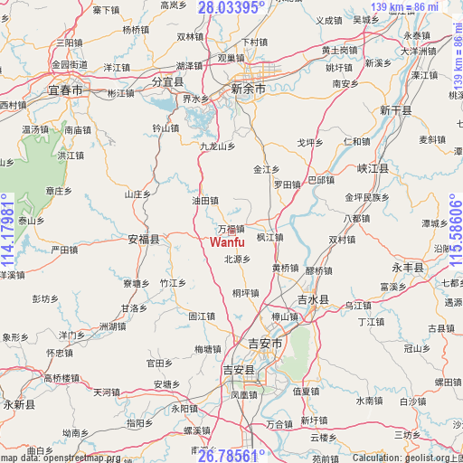
Wanfu GPS coordinates[2]
27° 24' 41.544" North, 114° 52' 58.548" East
| Map corner | latitude | longitude |
|---|---|---|
| Upper-left | 28.03395°, | 114.17981° |
| Center: | 27.41154°, | 114.88293° |
| Lower-right: | 26.78561°, | 115.58606° |
| Map W x H: | 138.8×138.8 km | = 86.2×86.2mi |
| max Lat: | 53.31946° ⇑76.9% North |
| Wanfu: | 27.41154° |
| min Lat: | ⇓23.1% South 18.22056° |
| min Long | Wanfu | max Long |
| 75.07348° | 114.88293° | 134.28917° |
| W 53.6%⇐ | ⇒46.4% E |
Elevation
Elevation of Wanfu is 55 m = 180 ft, and this is 429.8 m = 1410 ft below average elevation for this country.
| Max E: |
5622 m = 18445 ft | 69.2% |
| Avg. | 484.8 m = 1591 ft | |
| Wanfu | 55 m = 180 ft | |
Min E: |
-3 m = -10 ft | 30.8% |
See also: China elevation on elevation.city.
Geographical zone
Wanfu is located in North temperate zone (between Tropic of Cancer and the Arctic Circle). Distance of this Northern Tropic circle is 442 km =274.6 mi to South.| Distance of | km | miles | from Wanfu |
|---|---|---|---|
| North Pole | 6959.2 | 4324.2 | to North |
| Arctic Circle | 4353.3 | 2705 | to North |
| Tropic Cancer | 442 | 274.6 | to South |
| Equator | 3047.9 | 1893.9 | to South |


Nearby cities:
15 places around Wanfu: (largest is in red/bold)
• Changtang
25.8 km =16 mi,  160°
160°
• Dachong
9.3 km =5.8 mi,  202°
202°
• Fengjiang
11.7 km =7.3 mi,  96°
96°
• Fengtian
19 km =11.8 mi,  256°
256°
• Futian
4.8 km =3 mi,  66°
66°
• Guashe
16.1 km =10 mi,  270°
270°
• Huangqiao
19 km =11.8 mi,  123°
123°
• Jinjiang
21.8 km =13.5 mi,  27°
27°
• Luotian
21.8 km =13.5 mi,  48°
48°
• Pangu
12.4 km =7.7 mi,  79°
79°
• Shangxian
9.6 km =6 mi,  126°
126°
• Shuitian
26.2 km =16.3 mi,  87°
87°
• Tongping
18.4 km =11.4 mi,  167°
167°
• Youtian
14.3 km =8.9 mi,  321°
321°
• Zhujiang
23.1 km =14.4 mi,  229°
229°
Sources, notices
• [Note1] Compared only with cities in China existing in our database
• [Src1] Map data: © OpenStreetMap contributors (CC-BY-SA)
• [Src2] Other city data from geonames.org with taken over terms of usage.
• [Src3] Geographical zone / Annual Mean Temperature by Robert A. Rohde @ Wikipedia
