Guashe geodata
Guashe (Jiangxi) is a seat of a fourth-order administrative division; located in China in Asia/Shanghai (GMT+8) time zone. In our database, there are 1268 cities with bigger population. Compared to other cities in China, 76.9% of cities are located further ↑North; 52.7% of cities are located further ←West and 61.3% of cities have higher elevation than Guashe. Note1


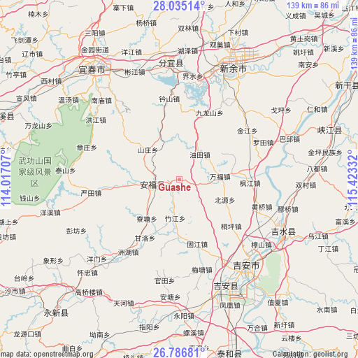
Guashe GPS coordinates[2]
27° 24' 45.864" North, 114° 43' 12.684" East
| Map corner | latitude | longitude |
|---|---|---|
| Upper-left | 28.03514°, | 114.01707° |
| Center: | 27.41274°, | 114.72019° |
| Lower-right: | 26.78681°, | 115.42332° |
| Map W x H: | 138.8×138.8 km | = 86.2×86.2mi |
| max Lat: | 53.31946° ⇑76.9% North |
| Guashe: | 27.41274° |
| min Lat: | ⇓23.1% South 18.22056° |
| min Long | Guashe | max Long |
| 75.07348° | 114.72019° | 134.28917° |
| W 52.7%⇐ | ⇒47.3% E |
Elevation
Elevation of Guashe is 91 m = 299 ft, and this is 393.8 m = 1292 ft below average elevation for this country.
| Max E: |
5622 m = 18445 ft | 61.3% |
| Avg. | 484.8 m = 1591 ft | |
| Guashe | 91 m = 299 ft | |
Min E: |
-3 m = -10 ft | 38.7% |
See also: China elevation on elevation.city.
Geographical zone
Guashe is located in North temperate zone (between Tropic of Cancer and the Arctic Circle). Distance of this Northern Tropic circle is 442.1 km =274.7 mi to South.| Distance of | km | miles | from Guashe |
|---|---|---|---|
| North Pole | 6959.1 | 4324.2 | to North |
| Arctic Circle | 4353.2 | 2705 | to North |
| Tropic Cancer | 442.1 | 274.7 | to South |
| Equator | 3048 | 1893.9 | to South |


Nearby cities:
15 places around Guashe: (largest is in red/bold)
• Chigu
16.6 km =10.3 mi,  336°
336°
• Dachong
15.2 km =9.4 mi,  124°
124°
• Fengtian
5.3 km =3.3 mi,  207°
207°
• Futian
20.5 km =12.7 mi,  84°
84°
• Gujiang
25.9 km =16.1 mi,  164°
164°
• Henglong
16.9 km =10.5 mi,  261°
261°
• Liaotang
19.8 km =12.3 mi,  219°
219°
• Litian
22.4 km =13.9 mi,  177°
177°
• Pingdu
11.3 km =7 mi,  254°
254°
• Shangxian
24.5 km =15.2 mi,  103°
103°
• Shanzhuang
16.7 km =10.4 mi,  313°
313°
• Songshan
25.1 km =15.6 mi,  346°
346°
• Wanfu
16.1 km =10 mi,  90°
90°
• Youtian
13.2 km =8.2 mi,  32°
32°
• Zhujiang
15.2 km =9.4 mi,  185°
185°
Sources, notices
• [Note1] Compared only with cities in China existing in our database
• [Src1] Map data: © OpenStreetMap contributors (CC-BY-SA)
• [Src2] Other city data from geonames.org with taken over terms of usage.
• [Src3] Geographical zone / Annual Mean Temperature by Robert A. Rohde @ Wikipedia
